
This post explains the expressways in India map together with the main national highways of India. The map numbers 20 routes: 12 fully operational expressways, four that are partly open, one that is still under construction, and three long national highway corridors – NH 44, NH 27 and the Golden Quadrilateral. Each route has a number on the map, and the same number is used in every table below.
Road questions in UPSC and State PSC papers usually ask you to match a highway or expressway with the states or cities it connects, to know which highway is the longest, or to explain a programme such as Bharatmala. New expressways such as the Ganga Expressway and the Delhi–Dehradun corridor, both opened in 2026, are also current-affairs material. Figures in this post are taken mainly from the Ministry of Road Transport and Highways (MoRTH) through the Press Information Bureau (PIB), and from the state agencies that built the expressways.
National Highways and Expressways of India Map
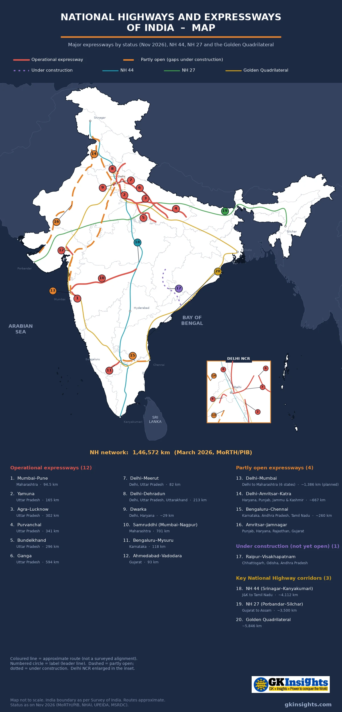
How to Read the Expressways in India Map
The map shows routes as lines, not points. The numbers are fixed and match the tables:
- Operational expressways (1–12) – solid lines. These are fully open, from the Mumbai–Pune Expressway of 2002 to the Ganga and Delhi–Dehradun expressways of 2026.
- Partly open expressways (13–16) – dashed lines. Long stretches carry traffic, but there are still gaps: Delhi–Mumbai, Delhi–Amritsar–Katra, Bengaluru–Chennai and Amritsar–Jamnagar.
- Under construction (17) – dotted line. The Raipur–Visakhapatnam Economic Corridor, not yet open end to end.
- Key national highway corridors (18–20) – thin lines drawn under the expressways: NH 44 (Srinagar–Kanyakumari), NH 27 (Porbandar–Silchar) and the Golden Quadrilateral linking Delhi, Mumbai, Chennai and Kolkata.
Routes on the map are approximate lines drawn through a few towns on each route, not surveyed alignments. They show the general direction, not the exact centre-line of the road. Only 20 routes are numbered so that the map stays readable; several shorter expressways, such as the ring roads around Delhi, are not shown. The map is not to scale.
National Highways of India: The Basics
India has the second-largest road network in the world, at 63.73 lakh km according to a PIB factsheet. National highways are a small part of this length, but they are the main arteries for long-distance passenger and freight traffic.
- Who declares them: roads are declared national highways by the Central Government under the National Highways Act, 1956. Highways declared by Parliament are a Union List subject; state highways and other roads are looked after by the states.
- Who builds them: MoRTH makes policy and plans the network. Projects are carried out by the National Highways Authority of India (NHAI), the National Highways and Infrastructure Development Corporation (NHIDCL, mainly in the North-East and border areas), and state public works departments.
- How long the network is: the national highways of India measured 1,46,572 km in March 2026, up from 91,287 km in 2014 – an increase of about 61% (PIB factsheet).
Older books and websites give different totals. Use the latest MoRTH/PIB figure and mention its date.
How National Highways Are Numbered
MoRTH adopted a new numbering system for national highways in April 2010. The number tells you the direction and rough position of the road:
- Even numbers are north–south highways. The numbers increase from east to west, so NH 2 is in the east and NH 48 in the west.
- Odd numbers are east–west highways. The numbers increase from north to south, so NH 1 is in the far north and higher odd numbers lie further south.
- Three-digit numbers are branches of a main highway; the last two digits show the parent. For example, NH 544 and NH 744 branch from NH 44.
- Suffixes such as A, B or BB mark smaller branches, as in NH 248BB, the Dwarka Expressway.
This is why many familiar old numbers changed after 2010; parts of several old highways, including the southern part of old NH 7, now form NH 44.
Expressway or National Highway: What Is the Difference?
An expressway is an access-controlled road. Vehicles can enter and leave only at fixed interchanges; there are no direct side entries, level crossings or traffic lights on the main carriageway; and slow vehicles are usually not allowed. An ordinary national highway can pass through towns and villages, with junctions and local traffic along the way.
Not every expressway is a national highway, and not every national highway is an expressway. The Yamuna, Agra–Lucknow, Purvanchal, Bundelkhand and Ganga expressways were built by Uttar Pradesh agencies, and the Mumbai–Pune and Samruddhi expressways by Maharashtra’s road corporation (MSRDC). Delhi–Mumbai, Delhi–Dehradun and Bengaluru–Mysuru are central projects built by NHAI.
How Many Kilometres of Expressways Does India Have?
There is no single figure, because sources count different things:
- MoRTH counts only central access-controlled roads. Its Year End Review 2025 says operational access-controlled high-speed corridors and expressways grew from 93 km in 2014 to 3,052 km, and later releases repeat this figure.
- Larger totals found on websites add state expressways and sometimes stretches that are only partly open, so they come out at several thousand kilometres more.
- MoRTH has also said that a total of 26,000 km of access-controlled high-speed corridors and expressways are targeted for award by 2032-33 (PIB).
In an answer, say whose figure you are using; the map here shows only the best-known routes.
Operational Expressways on the Expressways in India Map (1–12)
These 12 routes on the expressways in India map are fully open to traffic. Six of them are in Uttar Pradesh, which has built a connected set of state expressways since 2012.
| No. | Expressway | State(s) | Length | Opened / status | Notes for exams |
|---|---|---|---|---|---|
| 1 | Mumbai–Pune Expressway | Maharashtra | 94.5 km | Fully open April 2002 | Generally described as India’s first access-controlled expressway; built by MSRDC; crosses the Western Ghats near Khandala |
| 2 | Yamuna Expressway | Uttar Pradesh | 165 km | Opened August 2012 | Greater Noida to Agra, along the Yamuna; developed under the Yamuna Expressway Industrial Development Authority (YEIDA) |
| 3 | Agra–Lucknow Expressway | Uttar Pradesh | 302 km | Inaugurated 21 November 2016 | Six-lane greenfield road built by UPEIDA; has an airstrip for fighter aircraft in emergencies |
| 4 | Purvanchal Expressway | Uttar Pradesh | 341 km | Inaugurated 16 November 2021 | Lucknow to Ghazipur in eastern UP; inaugurated at the Kurebhar airstrip in Sultanpur district |
| 5 | Bundelkhand Expressway | Uttar Pradesh | 296 km | Inaugurated 16 July 2022 | Chitrakoot to Etawah, where it joins the Agra–Lucknow Expressway; four lanes; seven districts |
| 6 | Ganga Expressway | Uttar Pradesh | 594 km | Inaugurated 29 April 2026 | Meerut to Prayagraj through 12 districts; the longest expressway in Uttar Pradesh; has an IAF airstrip near Shahjahanpur |
| 7 | Delhi–Meerut Expressway | Delhi, Uttar Pradesh | About 82 km | Fully open to traffic April 2021 | The Delhi–UP Gate stretch has 14 lanes including service roads; built by NHAI |
| 8 | Delhi–Dehradun Expressway (Economic Corridor) | Delhi, Uttar Pradesh, Uttarakhand | 213 km | Inaugurated 14 April 2026 | 12 km elevated wildlife corridor near Rajaji National Park; Delhi–Dehradun travel time about 2.5 hours (PIB) |
| 9 | Dwarka Expressway (NH 248BB) | Delhi, Haryana | About 29 km | Haryana section March 2024; Delhi section 17 August 2025 | Urban expressway between Delhi and Gurugram; an eight-lane elevated road with service roads alongside |
| 10 | Mumbai–Nagpur Expressway (Samruddhi Mahamarg) | Maharashtra | 701 km | Fully open June 2025 | Built by MSRDC; the final Igatpuri–Amane stretch opened on 5 June 2025; the longest fully open expressway on this map |
| 11 | Bengaluru–Mysuru Expressway | Karnataka | 118 km | Inaugurated 12 March 2023 | NHAI project; links the state capital with Mysuru |
| 12 | Ahmedabad–Vadodara Expressway (NE-1) | Gujarat | About 93 km | Opened 2004 | Designated National Expressway 1; links two large cities of Gujarat |
Notes on the Operational Expressways
- Uttar Pradesh network (2–6): the Agra–Lucknow Expressway continues the Yamuna Expressway towards Lucknow, so Delhi is now linked to Lucknow by expressway. The Purvanchal carries the line east to Ghazipur, the Bundelkhand Expressway joins from the south near Etawah, and the Ganga Expressway runs diagonally from Meerut to Prayagraj.
- Ganga Expressway (6): built by UPEIDA, it is six lanes wide with structures built for eight. Some reports describe it as India’s longest expressway, but the Samruddhi Mahamarg (701 km) is longer and fully open. Safe wording: the longest expressway in Uttar Pradesh.
- Delhi–Dehradun (8): PIB says the corridor cut the distance from 235 km to 213 km and the travel time from over six hours to about two and a half. A 20 km stretch between Ganeshpur and Dehradun passes between Rajaji National Park and the Shivalik Reserve Forest, which is why it has the elevated wildlife corridor and a short tunnel near the Daat Kali temple (PIB).
- Samruddhi (10): it crosses Vidarbha and Marathwada and then the Western Ghats before reaching the Mumbai region.
Partly Open Routes on the Expressways in India Map (13–16)
These four are long corridors, but each still has gaps. Questions on them should be read carefully: an option that calls one of them “completed” is wrong as of November 2026.
| No. | Expressway | State(s) | Length | Opened / status | Notes for exams |
|---|---|---|---|---|---|
| 13 | Delhi–Mumbai Expressway | Delhi, Haryana, Rajasthan, Madhya Pradesh, Gujarat, Maharashtra | About 1,386 km planned (PIB); often given as about 1,350 km | Partly open; first section February 2023 | Partly open, not complete; Delhi to Thandla (MP) is continuous |
| 14 | Delhi–Amritsar–Katra Expressway | Haryana, Punjab, Jammu & Kashmir | About 670 km (approximate) | Partly open; about 190 km dedicated by July 2026 | Links Delhi with Amritsar and the pilgrimage town of Katra; the rest is to open in phases |
| 15 | Bengaluru–Chennai Expressway | Karnataka, Andhra Pradesh, Tamil Nadu | About 260 km (approximate) | Mostly built; a short stretch in Tamil Nadu still pending | Crosses the Chittoor area of Andhra Pradesh between the two cities |
| 16 | Amritsar–Jamnagar Expressway (Economic Corridor) | Punjab, Haryana, Rajasthan, Gujarat | About 1,224 km (PIB, May 2022) | Partly open; Rajasthan sections from 2023, Punjab stretches in 2026 | Links Punjab with the ports of Jamnagar and Kandla on the Gujarat coast; runs through the Thar region |
Notes on the Partly Open Expressways
- Delhi–Mumbai (13): PIB gives a planned length of about 1,386 km and a cost of about Rs 1 lakh crore. The 246 km Delhi–Dausa–Lalsot stretch was the first to open, on 12 February 2023, followed by Vadodara–Bharuch (87 km) on 22 February 2024 and two Gujarat sections on 5 June 2026. In March 2026 the Road Minister told the Rajya Sabha that 929 km of the project’s 1,445 km scope was operational. That figure includes connecting spurs, which is why lengths of 1,350 km to 1,445 km are all quoted. Gaps near the Madhya Pradesh–Gujarat border and in south Gujarat were still being built as of November 2026.
- Delhi–Amritsar–Katra (14): reported lengths are about 667–669 km. Stretches in Haryana and Punjab, together about 190 km, were dedicated in July 2026; the rest is to open in phases.
- Bengaluru–Chennai (15): news reports in November 2026 say about 230 km is complete and a stretch of roughly 14 km in Tamil Nadu has been re-tendered.
- Amritsar–Jamnagar (16): a PIB release of May 2022 described it as a 1,224 km corridor linking Amritsar, Bathinda, Sangaria, Bikaner, Sanchore, Samakhiyali and Jamnagar. Later unofficial figures vary, which is why the map key does not print a length. Several Rajasthan sections opened from July 2023 and some Punjab stretches in 2026.
Under Construction: Raipur–Visakhapatnam Economic Corridor (17)
The Raipur–Visakhapatnam Economic Corridor (17) runs from Chhattisgarh through Odisha to the Andhra Pradesh coast. A PIB release of January 2026 describes it as a 464 km, six-lane access-controlled highway costing Rs 16,491 crore, and as Chhattisgarh’s first six-lane access-controlled highway.
| No. | Expressway | State(s) | Length | Opened / status | Notes for exams |
|---|---|---|---|---|---|
| 17 | Raipur–Visakhapatnam Economic Corridor | Chhattisgarh, Odisha, Andhra Pradesh | 464 km (PIB) | Under construction; not yet open end to end | Links the iron-ore and industrial belt of Chhattisgarh with Visakhapatnam Port; 2.79 km twin-tube tunnel under the Udanti–Sitanadi Tiger Reserve |
The route is a good example of geography shaping a road. It crosses the forested Dandakaranya uplands and the Eastern Ghats, close to protected forests. The tunnel, animal underpasses and overpasses are meant to keep tiger and other wildlife corridors intact. PIB expected travel time between Raipur and Visakhapatnam to fall from about 12 hours to 6–7 hours. Its main economic purpose is to carry minerals and goods from the mineral belt of central India to a major port.
Key National Highway Corridors (18–20)
Three long corridors are drawn under the expressways. They are not expressways, but they are the backbone of the national highways of India and appear often in exam questions.
| No. | Corridor | Runs between | Length | Notes for exams |
|---|---|---|---|---|
| 18 | NH 44 | Srinagar (J&K) to Kanyakumari (Tamil Nadu) | About 4,112 km | The longest national highway in India; forms most of the North–South Corridor; passes through Jammu & Kashmir, Punjab, Haryana, Delhi, Uttar Pradesh, Rajasthan, Madhya Pradesh, Maharashtra, Telangana, Andhra Pradesh, Karnataka and Tamil Nadu |
| 19 | NH 27 | Porbandar (Gujarat) to Silchar (Assam) | Roughly 3,500 km (figures vary) | Main route of the East–West Corridor; crosses northern India and reaches the North-East through the Siliguri Corridor |
| 20 | Golden Quadrilateral | Delhi – Mumbai – Chennai – Kolkata – Delhi | About 5,846 km | Phase I of the National Highways Development Project (NHDP); declared complete in January 2012; today mostly NH 48, NH 16 and NH 19 |
Longest National Highway in India: NH 44
The longest national highway in India is NH 44, which runs from Srinagar to Kanyakumari, a length of about 4,112 km. It passes through Jammu, Jalandhar, Panipat, Delhi, Agra, Gwalior, Jhansi, Nagpur, Hyderabad, Bengaluru, Salem and Madurai. NH 44 was formed in 2010 by joining parts of several older highways, including the southern part of old NH 7; this is why older books name old NH 7 (Varanasi–Kanyakumari) as the longest.
Because it was stitched together from older roads, the exact length differs slightly between sources. Write “about 4,112 km”, which is the figure used on the map, rather than a number to the last kilometre.
East–West Corridor and NH 27
NH 27 runs from Porbandar on the Saurashtra coast through Rajasthan, Madhya Pradesh, Uttar Pradesh, Bihar and West Bengal to Assam, ending at Silchar. It is often listed as the second-longest national highway. Its eastern part passes through the narrow Siliguri Corridor, the only land link between the North-East and the rest of India, which gives it strategic value.
North–South and East–West Corridor
Under the NHDP, the North–South Corridor (Srinagar to Kanyakumari, with a spur to Kochi) and the East–West Corridor (Silchar to Porbandar) were planned to cross the country. They are commonly given as about 4,000 km and 3,300 km, together about 7,300 km. The two corridors meet at Jhansi in Uttar Pradesh. On the map, NH 44 (18) and NH 27 (19) follow these corridors closely.
Golden Quadrilateral
The Golden Quadrilateral (20) joins the four metropolitan cities – Delhi, Mumbai, Chennai and Kolkata – in a loop of about 5,846 km. It was Phase I of the NHDP, started in the early 2000s, and was declared complete in January 2012. Today the Delhi–Mumbai–Chennai side is mostly NH 48 (via Jaipur, Ahmedabad, Mumbai, Pune and Bengaluru), the Chennai–Kolkata side NH 16 along the east coast, and the Kolkata–Delhi side NH 19 through Dhanbad, Varanasi, Prayagraj, Kanpur and Agra. The four metros are also the busiest airport hubs, and three of them are port cities.
Highway Programmes Behind the National Highways of India
Most of the national highways of India built since 2000 came under two big programmes.
| Programme | Started | What it covers |
|---|---|---|
| National Highways Development Project (NHDP) | Late 1990s / early 2000s | Phased widening programme: Phase I Golden Quadrilateral, Phase II North–South and East–West Corridors, later phases for other highways and expressways |
| Bharatmala Pariyojana | Approved October 2017 | 34,800 km of national highway corridors at an estimated Rs 5.35 lakh crore, including economic corridors, inter-corridor and feeder roads, border and coastal roads, and expressways |
| High-speed corridors (current plan) | Ongoing | Target of 26,000 km of access-controlled corridors and expressways to be awarded by 2032-33 |
According to PIB, 26,425 km had been awarded and 22,590 km built under Bharatmala by 31 March 2026. Many of the new expressways on the map – Delhi–Mumbai, Delhi–Amritsar–Katra, Amritsar–Jamnagar, Bengaluru–Chennai and Raipur–Visakhapatnam – are Bharatmala corridors. The UP expressways and Samruddhi are state projects, outside Bharatmala.
Expressways in India: State-wise Picture
Counting only the 17 expressways numbered on the expressways in India map, the state-wise picture looks like this:
| State / UT | Numbered expressways on the map |
|---|---|
| Uttar Pradesh | Yamuna (2), Agra–Lucknow (3), Purvanchal (4), Bundelkhand (5), Ganga (6), Delhi–Meerut (7), Delhi–Dehradun (8) |
| Maharashtra | Mumbai–Pune (1), Samruddhi (10), Delhi–Mumbai (13, southern end) |
| Gujarat | Ahmedabad–Vadodara (12), Delhi–Mumbai (13), Amritsar–Jamnagar (16) |
| Rajasthan | Delhi–Mumbai (13), Amritsar–Jamnagar (16) |
| Haryana | Dwarka (9), Delhi–Mumbai (13), Delhi–Amritsar–Katra (14), Amritsar–Jamnagar (16) |
| Punjab | Delhi–Amritsar–Katra (14), Amritsar–Jamnagar (16) |
| Delhi | Delhi–Meerut (7), Delhi–Dehradun (8), Dwarka (9), Delhi–Mumbai (13) |
| Karnataka | Bengaluru–Mysuru (11), Bengaluru–Chennai (15) |
| Chhattisgarh, Odisha, Andhra Pradesh | Raipur–Visakhapatnam (17); Andhra Pradesh also has part of Bengaluru–Chennai (15) |
Uttar Pradesh stands out because its state government built a chain of greenfield expressways across the Ganga plain. The expressways link the western districts near Delhi with eastern UP and Bundelkhand.
Geography Behind the Expressways in India Map
Read the expressways in India map as a geography map, not only a list of roads. A few patterns help in descriptive answers:
- Plains first: the Ganga plain and the plains of Gujarat and Punjab have the densest set of expressways, because land is flat, cities are close together and traffic is heavy.
- Crossing the Ghats: Mumbai–Pune and Samruddhi climb the Western Ghats, and the Raipur–Visakhapatnam corridor crosses the Eastern Ghats; such stretches need tunnels, viaducts and careful slope work. The mountain ranges of India post shows these ranges.
- Wildlife and forests: Delhi–Dehradun (near Rajaji) and Raipur–Visakhapatnam (Udanti–Sitanadi) use elevated sections, tunnels and animal crossings. Compare with the wildlife sanctuaries in India map.
- Ports and freight: Amritsar–Jamnagar and Delhi–Mumbai carry freight to west coast ports, and Raipur–Visakhapatnam links Chhattisgarh’s mineral and power belt with the east coast.
- Defence use: airstrips built on expressways – on the Agra–Lucknow, Purvanchal and Ganga expressways – allow Air Force aircraft to land in emergencies.
- Mountains: in the Himalaya, ordinary national highways remain the main links, and high mountain passes close in winter.
Exam Traps on the Expressways in India Map
These are the points where answers most often go wrong. Check each one against the numbered expressways in India map.
- Longest national highway: NH 44 (Srinagar–Kanyakumari), not old NH 7, a number that disappeared in the 2010 renumbering.
- Longest expressway: the Delhi–Mumbai Expressway (13) is only partly open, so it should not be called the longest expressway yet. Among fully open expressways on the map, Samruddhi (701 km) is longer than the Ganga Expressway (594 km).
- First expressway: the Mumbai–Pune Expressway (1), fully open in 2002, is generally named as the first access-controlled expressway in India. The Ahmedabad–Vadodara Expressway (12) carries the designation National Expressway 1.
- NH numbering: even numbers run north–south, odd numbers east–west. Do not swap them.
- Golden Quadrilateral vs corridors: the Golden Quadrilateral links the four metros; the North–South and East–West Corridors cross the country and meet at Jhansi.
- Expressway length: MoRTH’s 3,052 km counts only central access-controlled roads. Larger totals include state expressways. Name the source.
- Agency: the UP expressways (2–6) were built by state agencies (UPEIDA; YEIDA for Yamuna), not NHAI. Delhi–Meerut, Delhi–Dehradun and Bengaluru–Mysuru are NHAI projects.
- Status words: check whether a question asks about operational, partly open or planned roads. Completion targets for long corridors have moved more than once.
Route-wise Facts for Revision
Read these one-line facts along with the expressways in India map and the national highways of India shown on it.
| Fact | Route (map no.) |
|---|---|
| Longest national highway in India | NH 44, Srinagar–Kanyakumari (18) |
| Main East–West Corridor highway, Porbandar–Silchar | NH 27 (19) |
| Loop joining Delhi, Mumbai, Chennai and Kolkata | Golden Quadrilateral (20) |
| Generally named the first access-controlled expressway (2002) | Mumbai–Pune (1) |
| Designated National Expressway 1 | Ahmedabad–Vadodara (12) |
| Longest expressway in Uttar Pradesh (594 km) | Ganga Expressway (6) |
| 701 km, Mumbai to Nagpur, fully open 2025 | Samruddhi Mahamarg (10) |
| 12 km elevated wildlife corridor near Rajaji National Park | Delhi–Dehradun (8) |
| Partly open; planned length about 1,386 km (PIB) | Delhi–Mumbai (13) |
| Tunnel under the Udanti–Sitanadi Tiger Reserve | Raipur–Visakhapatnam (17) |
UPSC Practice Points on National Highways of India
These points sum up the facts most likely to be asked about the national highways of India and expressways in Prelims and State PSC papers.
- Road network: 63.73 lakh km, second largest in the world (PIB).
- National highways: 1,46,572 km (March 2026), up from 91,287 km in 2014 (PIB).
- Operational central access-controlled corridors and expressways: 93 km (2014) to 3,052 km (PIB, December 2025).
- NH numbering since April 2010: even numbers north–south, odd numbers east–west, three digits for branches.
- Bharatmala Pariyojana: approved October 2017; 34,800 km; Rs 5.35 lakh crore; 22,590 km built by 31 March 2026.
- Golden Quadrilateral: about 5,846 km; NHDP Phase I; declared complete January 2012.
- New expressways in 2026: Delhi–Dehradun (14 April 2026, 213 km) and Ganga (29 April 2026, 594 km).
- Revise with the major airports in India map and major ports in India map.
FAQs on National Highways and Expressways of India Map
Which is the longest national highway in India?
NH 44 is the longest national highway in India. It runs from Srinagar in Jammu and Kashmir to Kanyakumari in Tamil Nadu, a length of about 4,112 km, and forms most of the North–South Corridor.
What is the total length of national highways in India?
According to MoRTH figures released through PIB, the national highways of India measured 1,46,572 km in March 2026, up from 91,287 km in 2014.
Which is the longest expressway in India?
The Delhi–Mumbai Expressway is only partly open as of November 2026; its planned length is about 1,386 km (PIB). It should not be called the longest expressway until it is finished. Among fully open expressways, the 701 km Mumbai–Nagpur Samruddhi Mahamarg is longer than the 594 km Ganga Expressway.
Which was the first expressway in India?
The Mumbai–Pune Expressway, fully open in April 2002, is generally described as India’s first access-controlled expressway. The Ahmedabad–Vadodara Expressway is designated National Expressway 1.
How are national highways numbered in India?
Since April 2010, north–south highways have even numbers that increase from east to west, and east–west highways have odd numbers that increase from north to south. Three-digit numbers are branches of a main highway.
What is the difference between the Golden Quadrilateral and the North–South and East–West Corridors?
The Golden Quadrilateral is a loop of about 5,846 km joining Delhi, Mumbai, Chennai and Kolkata. The North–South Corridor runs from Srinagar to Kanyakumari and the East–West Corridor from Silchar to Porbandar; the two corridors cross at Jhansi.
What do the numbers on the expressways in India map show?
They mark 20 routes: 1–12 are fully operational expressways, 13–16 partly open expressways, 17 is the Raipur–Visakhapatnam corridor under construction, and 18–20 are NH 44, NH 27 and the Golden Quadrilateral. The same numbers are used in the tables.
Also Check:
– Major Airports in India Map
– Major Ports in India Map
– Important Mountain Passes in India Map
– Plateaus of India Map
– Minerals in India Map
– Thermal Power Plants in India Map
– National Parks in India Map
– Wildlife Sanctuaries in India Map