
India has hundreds of waterfalls, from the high plunges of the Meghalaya plateau to the wide falls of the Indravati in Chhattisgarh and the monsoon-fed falls of the Western Ghats. Questions on waterfalls usually ask for the state, the river that forms the fall, or which fall is the highest or widest. This post gives a waterfalls in India map, a region-wise list of important waterfalls with their rivers, the highest waterfalls of India, and the facts that come up most often in UPSC Prelims, State PSC and other competitive exams.
Waterfalls in India Map
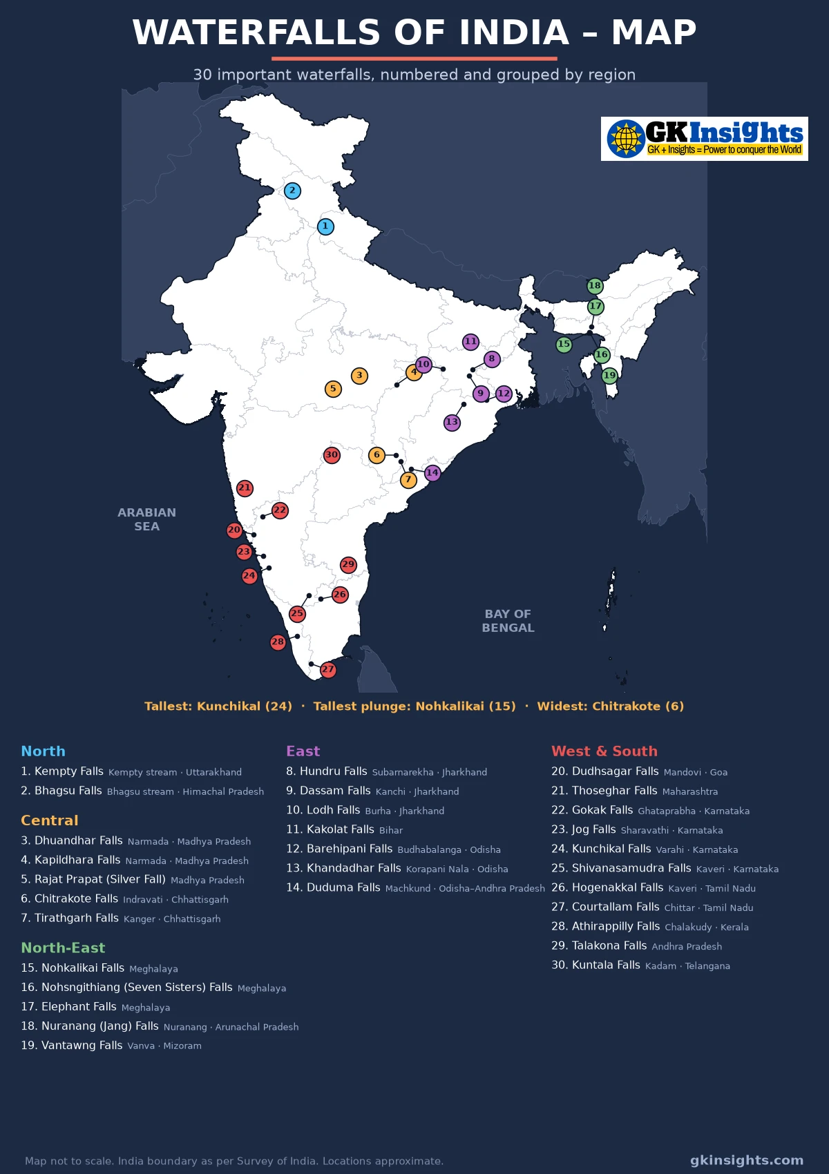
The map above marks 30 important waterfalls of India, grouped into five regions. Most of them lie on the edges of plateaus and hill ranges, where rivers drop from a higher surface to a lower one: the Western Ghats, the Chota Nagpur Plateau, the Bastar Plateau, the Vindhya and Satpura ranges and the Meghalaya Plateau. Learn each waterfall together with its river and state.
How are Waterfalls Formed?
A waterfall forms where a river flows over a sudden drop in its bed. This usually happens where a layer of hard rock lies over softer rock. The river wears away the soft rock below faster than the hard rock above, so a steep step forms and the water falls over it. Waterfalls also form at the edge of a plateau, along a fault line, or where a glacier has deepened a main valley and left the side valleys hanging high above it.
Over time the falling water cuts back into the cliff, and the waterfall slowly moves upstream. This leaves a narrow, steep-sided gorge below it, as seen at Dhuandhar Falls on the Narmada, where the river flows through the marble rocks of Bhedaghat.
Types of Waterfalls
- Plunge: the water falls straight down and loses contact with the rock face, as at Nohkalikai and Jog Falls.
- Tiered: the water falls in a series of steps, each with its own drop, as at Kunchikal, Barehipani and Dudhsagar.
- Horsetail: the water falls down while keeping contact with the rock behind it, as at Khandadhar and Duduma.
- Cataract: a large, powerful waterfall with a big volume of water, often wide rather than high, as at Chitrakote and Hogenakkal.
- Segmented: the water splits into several separate streams as it falls, as at Nohsngithiang (Seven Sisters) Falls.
Highest Waterfalls in India
The heights below are the figures usually given in exam books and in the World Waterfall Database. Heights of waterfalls are hard to measure, so different sources give slightly different numbers. Some newer lists also rank the Vajrai Falls in Satara, Maharashtra, above Kunchikal, but most exam material still names Kunchikal as the highest waterfall in India.
| Waterfall | State | Height (about) | Type |
|---|---|---|---|
| Kunchikal Falls | Karnataka (Shivamogga) | 455 m | Tiered; usually named the highest waterfall in India |
| Barehipani Falls | Odisha (Mayurbhanj, Similipal) | 399 m | Tiered; highest waterfall in Odisha |
| Nohkalikai Falls | Meghalaya (East Khasi Hills) | 340 m | Plunge; tallest plunge waterfall in India |
| Nohsngithiang (Seven Sisters) Falls | Meghalaya (East Khasi Hills) | 315 m | Segmented |
| Dudhsagar Falls | Goa (on the Goa–Karnataka border) | 310 m | Tiered |
| Jog Falls | Karnataka (Shivamogga) | 253 m | Plunge |
| Khandadhar Falls | Odisha (Sundargarh) | 244 m | Horsetail |
| Vantawng Falls | Mizoram (Serchhip) | 229 m | Tiered; highest waterfall in Mizoram |
List of Important Waterfalls in India (Region-wise)
North India
| Waterfall | River | State | Key fact |
|---|---|---|---|
| Kempty Falls | Kempty stream | Uttarakhand | Near Mussoorie in the Garhwal Himalaya |
| Bhagsu Falls | Bhagsu stream | Himachal Pradesh | Near McLeod Ganj, Dharamshala, in the Dhauladhar range |
Central India
| Waterfall | River | State | Key fact |
|---|---|---|---|
| Dhuandhar Falls | Narmada | Madhya Pradesh | At Bhedaghat near Jabalpur; the spray looks like smoke (dhuan), and the river flows through a marble gorge |
| Kapildhara Falls | Narmada | Madhya Pradesh | First major fall of the Narmada, close to its source at Amarkantak |
| Rajat Prapat (Silver Fall) | Stream in the Satpura hills | Madhya Pradesh | Near Pachmarhi; one of the highest falls of Madhya Pradesh, at about 107 m |
| Chitrakote Falls | Indravati | Chhattisgarh | Near Jagdalpur in Bastar; the widest waterfall in India, often called the “Niagara of India” |
| Tirathgarh Falls | Kanger | Chhattisgarh | Inside Kanger Valley National Park, Bastar |
East India
| Waterfall | River | State | Key fact |
|---|---|---|---|
| Hundru Falls | Subarnarekha | Jharkhand | Near Ranchi, at the edge of the Ranchi Plateau |
| Dassam Falls | Kanchi (tributary of the Subarnarekha) | Jharkhand | Near Ranchi; one of the best-known falls of the Chota Nagpur Plateau |
| Lodh Falls (Burha Ghagh) | Burha | Jharkhand | In Latehar district; highest waterfall in Jharkhand, at about 143 m |
| Kakolat Falls | Hill stream | Bihar | In Nawada district; a well-known waterfall of Bihar |
| Barehipani Falls | Budhabalanga | Odisha | Inside Similipal National Park; highest waterfall in Odisha |
| Khandadhar Falls | Korapani Nala | Odisha | In Sundargarh district; the name means a fall shaped like a sword (khanda) |
| Duduma Falls | Machkund | Odisha–Andhra Pradesh border | Water of the Machkund is used by the Machkund hydroelectric project |
North-East India
| Waterfall | River | State | Key fact |
|---|---|---|---|
| Nohkalikai Falls | Stream from the Meghalaya Plateau | Meghalaya | Near Sohra (Cherrapunji); tallest plunge waterfall in India |
| Nohsngithiang (Seven Sisters) Falls | Stream near Mawsmai | Meghalaya | Near Sohra; the water splits into seven streams in the monsoon |
| Elephant Falls | Hill stream | Meghalaya | Near Shillong; a three-step fall |
| Nuranang (Jang) Falls | Nuranang | Arunachal Pradesh | In Tawang district, near Jang |
| Vantawng Falls | Vanva | Mizoram | In Serchhip district; highest waterfall in Mizoram |
West and South India
| Waterfall | River | State | Key fact |
|---|---|---|---|
| Dudhsagar Falls | Mandovi | Goa | On the Goa–Karnataka border in Bhagwan Mahavir Wildlife Sanctuary; the white, milky water gives it its name (sea of milk) |
| Thoseghar Falls | Hill stream | Maharashtra | In Satara district in the Western Ghats |
| Gokak Falls | Ghataprabha | Karnataka | In Belagavi district; a wide fall over sandstone cliffs |
| Jog Falls (Gersoppa Falls) | Sharavathi | Karnataka | In Shivamogga district; falls in four streams named Raja, Rani, Roarer and Rocket |
| Kunchikal Falls | Varahi | Karnataka | Near Agumbe in Shivamogga district; usually named the highest waterfall in India |
| Shivanasamudra Falls | Kaveri | Karnataka | Twin falls, Gaganachukki and Bharachukki; site of one of the first hydroelectric power stations in Asia, started in 1902 |
| Hogenakkal Falls | Kaveri | Tamil Nadu | In Dharmapuri district; known for coracle rides and also called the “Niagara of India” |
| Courtallam (Kutralam) Falls | Chittar | Tamil Nadu | In Tenkasi district; known as the “Spa of South India” |
| Athirappilly Falls | Chalakudy | Kerala | In Thrissur district; the largest waterfall of Kerala, also called the “Niagara of India” |
| Talakona Falls | Hill stream | Andhra Pradesh | In Sri Venkateswara National Park; highest waterfall in Andhra Pradesh |
| Kuntala Falls | Kadam | Telangana | In Adilabad (Nirmal area); highest waterfall in Telangana |
Waterfalls and Their Rivers: Quick Revision
| River | Waterfalls on it |
|---|---|
| Kaveri | Shivanasamudra (Karnataka), Hogenakkal (Tamil Nadu) |
| Narmada | Kapildhara (near Amarkantak), Dhuandhar (Bhedaghat, Jabalpur) |
| Sharavathi | Jog Falls (Karnataka) |
| Indravati | Chitrakote (Chhattisgarh) |
| Subarnarekha | Hundru (Jharkhand) |
| Mandovi | Dudhsagar (Goa) |
| Machkund | Duduma (Odisha–Andhra Pradesh) |
| Ghataprabha | Gokak (Karnataka) |
| Chalakudy | Athirappilly (Kerala) |
Key Facts for UPSC and Other Exams
- Highest waterfall: Kunchikal Falls, Karnataka, about 455 m, is usually named the highest waterfall in India.
- Tallest plunge waterfall: Nohkalikai Falls near Sohra, Meghalaya.
- Widest waterfall: Chitrakote Falls on the Indravati, Chhattisgarh.
- “Niagara of India”: this name is used for Chitrakote, Hogenakkal and Athirappilly in different books. If a question uses it, check the river and state given in the options.
- Hydroelectric power: Shivanasamudra on the Kaveri was among the first places in Asia to generate hydroelectric power (1902). Jog Falls feeds the Sharavathi hydroelectric project, and Duduma feeds the Machkund project.
- Western Ghats: rivers flowing west, such as the Sharavathi and Varahi, drop steeply down the Ghats, which is why Karnataka has many of India’s highest falls.
- Plateau falls: the Chota Nagpur Plateau around Ranchi has Hundru, Dassam and Jonha falls, so Ranchi is sometimes called the “City of Waterfalls”.
UPSC usually tests waterfalls through match-the-following questions with rivers and states, or by asking which river a famous fall lies on. Read this list together with the rivers of India and the major dams list, since many waterfalls are close to dams and hydroelectric projects.
FAQs on Waterfalls in India
Which is the highest waterfall in India?
Kunchikal Falls in Shivamogga district of Karnataka, formed by the Varahi river, is usually named the highest waterfall in India, with a height of about 455 m. Some newer lists rank the Vajrai Falls in Satara, Maharashtra, higher.
Which is the tallest plunge waterfall in India?
Nohkalikai Falls near Sohra (Cherrapunji) in Meghalaya, about 340 m high, is the tallest plunge waterfall in India.
Which is the widest waterfall in India?
Chitrakote Falls on the Indravati river near Jagdalpur, Chhattisgarh, is the widest waterfall in India. It is often called the Niagara of India.
On which river is Jog Falls?
Jog Falls, also called Gersoppa Falls, is on the Sharavathi river in Shivamogga district of Karnataka. It falls in four streams called Raja, Rani, Roarer and Rocket.
Which waterfalls are on the Kaveri river?
Shivanasamudra Falls in Karnataka and Hogenakkal Falls in Tamil Nadu are the two best-known waterfalls on the Kaveri.
Where is Dudhsagar Falls?
Dudhsagar Falls is on the Mandovi river on the Goa–Karnataka border, inside the Bhagwan Mahavir Wildlife Sanctuary of Goa. It is about 310 m high.
Also Check:
– Rivers of India – Coloured Map and List
– Mountains, Ranges and Hills of India – Map
– Major Dams in India – Map and List
– Wildlife Sanctuaries in India – Map and List
– National Parks in India – Map and List