
This post explains the minerals in India map with 37 numbered mining areas of iron ore, coal, bauxite, manganese, copper and other minerals. You will also learn the types of minerals, mineral belts, leading states and mining laws for UPSC and State PSC exams.
As per the Ministry of Mines, India produces 95 minerals: 4 fuel minerals, 10 metallic, 27 non-metallic, 3 atomic and 51 minor minerals.
Minerals in India Map
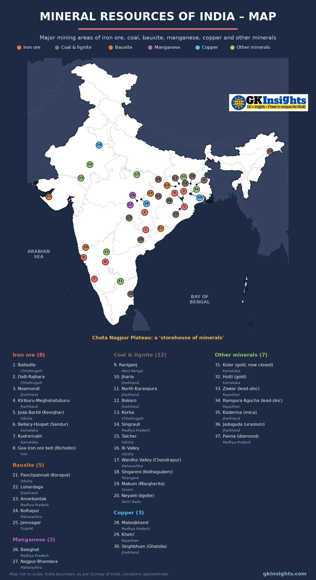
How to Read the Minerals in India Map
On the minerals in India map above, each dot has a number and a colour. Red is iron ore (1–8), brown is coal and lignite (9–20), orange is bauxite (21–25), purple is manganese (26–27), light blue is copper (28–30) and green is other minerals (31–37). Locations are approximate and the map is not to scale.
Most dots on the minerals in India map sit in Jharkhand, Odisha, Chhattisgarh and Madhya Pradesh. This is the Chota Nagpur Plateau and nearby areas, often called the storehouse of minerals of India. Other groups lie in Karnataka and Goa, and in the Aravalli hills of Rajasthan. The northern plains have almost no dots, because they are made of young river deposits.
What are Minerals?
A mineral is a natural substance with a definite chemical make-up. When a rock has enough of a mineral to be mined at a profit, it is called an ore. For example, haematite is an ore of iron and bauxite is an ore of aluminium.
Copper and zinc form in cracks of hard igneous and metamorphic rocks, while coal forms in layers of sedimentary rocks. So rock type decides which minerals a region has, and this is why the minerals in India map looks so uneven.
Classification of Minerals
| Type | Sub-type | Examples |
|---|---|---|
| Metallic | Ferrous (contain iron) | Iron ore, manganese, chromite, nickel, cobalt |
| Metallic | Non-ferrous | Copper, bauxite (aluminium), lead, zinc, gold, silver, tin |
| Non-metallic | – | Limestone, mica, gypsum, dolomite, phosphorite, graphite |
| Energy (fuel) | Fossil fuels | Coal, lignite, petroleum, natural gas |
| Energy (atomic) | – | Uranium, thorium |
By law, minerals are major or minor. Major minerals such as iron ore and coal come under central rules, though States grant the leases. Minor minerals such as sand and building stone are controlled by the States. The minerals in India map shows only major minerals.
Mineral Belts of India
NCERT describes three broad mineral belts: the North-Eastern Plateau, the South-Western Plateau and the North-Western region. Many textbooks also list a Central belt. You can trace all four on the minerals in India map.
- Chota Nagpur or North-Eastern Plateau belt: Jharkhand, Odisha, West Bengal and parts of Chhattisgarh, with coal, iron ore, bauxite, copper, mica and uranium. Dots 3, 4, 5, 9 to 12, 15, 16, 21, 22, 30, 35 and 36 on the minerals in India map fall here.
- Central belt: Chhattisgarh, Madhya Pradesh and eastern Maharashtra, with iron ore, manganese, bauxite, copper, coal and diamonds.
- Southern or Dharwar belt: Karnataka, Goa and nearby areas. The old Dharwar rocks hold iron ore and gold.
- North-Western or Aravalli belt: Rajasthan and Gujarat, with copper, lead, zinc and bauxite.
Petroleum and natural gas come from sedimentary basins in Assam, Gujarat and offshore Mumbai High, so they are not shown on the minerals in India map.
Iron Ore Mines on the Minerals in India Map (1–8)
Iron ore is the base of the steel industry. India has two main ores. Haematite is the most widely used ore, and magnetite is a very high-grade ore that is often magnetic. India has about 27,555 million tonnes of haematite and 11,321 million tonnes of magnetite resources (National Mineral Inventory, 1.4.2025). Red dots on the minerals in India map mark the main iron ore mines in India.
| No. | Mine / area | State (district) | Operator | Key fact |
|---|---|---|---|---|
| 1 | Bailadila | Chhattisgarh (Dantewada) | NMDC | High-grade haematite in the Bailadila hills; NMDC’s Kirandul and Bacheli mines |
| 2 | Dalli-Rajhara | Chhattisgarh (Balod) | SAIL | Captive mines that feed the Bhilai Steel Plant |
| 3 | Noamundi | Jharkhand (West Singhbhum) | Tata Steel | Supplies iron ore to Tata Steel’s Jamshedpur works |
| 4 | Kiriburu-Meghahatuburu | Jharkhand (West Singhbhum) | SAIL | Lies on the Jharkhand–Odisha border; NCERT lists Kiriburu under Odisha (Kendujhar) |
| 5 | Joda-Barbil (Keonjhar) | Odisha (Keonjhar) | Several public and private miners | Hub of Odisha’s iron ore belt |
| 6 | Bellary-Hospet (Sandur) | Karnataka (Ballari, Vijayanagara) | NMDC and private miners | Haematite in the Sandur hills; NMDC’s Donimalai mine is here |
| 7 | Kudremukh | Karnataka (Chikkamagaluru) | KIOCL (formerly) | Magnetite mine in the Western Ghats; mining stopped at the end of 2005 on Supreme Court orders, as the area is a National Park |
| 8 | Goa iron ore belt (Bicholim) | Goa (North Goa) | Auctioned blocks (Bicholim block: Vedanta) | Halted in 2018 after the Supreme Court quashed leases; restarted in 2024 under auctions |
As per the Ministry of Mines, India produced a record 312.5 million tonnes of iron ore in 2025–26 (provisional). PIB (August 2026) ranks India fourth in the world in iron ore. Odisha, Chhattisgarh and Karnataka are the top producers, and all three carry red dots on the minerals in India map.
Coal Fields in India on the Map (9–20)
Coal is India’s most important energy mineral. Most of it is Gondwana coal, formed over 200 million years ago and found in the river valleys of the Damodar, Mahanadi, Son, Godavari and Wardha. A small amount is younger Tertiary coal of the North-East. Lignite is a low-grade, moist brown coal. Brown dots on the minerals in India map show the coal fields in India.
| No. | Mine / area | State (district) | Operator | Key fact |
|---|---|---|---|---|
| 9 | Raniganj | West Bengal (Paschim Bardhaman) | Eastern Coalfields (ECL) | Commercial coal mining in India began here in 1774 |
| 10 | Jharia | Jharkhand (Dhanbad) | Bharat Coking Coal (BCCL) | Main source of prime coking coal; known for mine fires |
| 11 | North Karanpura | Jharkhand (Hazaribagh, Chatra) | Central Coalfields (CCL) | One of the largest coalfields of the Damodar valley |
| 12 | Bokaro | Jharkhand (Bokaro and nearby districts) | Central Coalfields (CCL) | Damodar valley coalfield with medium coking coal |
| 13 | Korba | Chhattisgarh (Korba) | South Eastern Coalfields (SECL) | Has Gevra, India’s largest coal mine, and Kusmunda |
| 14 | Singrauli | Madhya Pradesh (Singrauli); extends into Uttar Pradesh | Northern Coalfields (NCL) | Feeds a cluster of large pithead power stations |
| 15 | Talcher | Odisha (Angul) | Mahanadi Coalfields (MCL) | Large field in the Brahmani valley |
| 16 | Ib Valley | Odisha (Jharsuguda, Sundargarh) | Mahanadi Coalfields (MCL) | Second big field of Odisha in the Mahanadi basin |
| 17 | Wardha Valley (Chandrapur) | Maharashtra (Chandrapur) | Western Coalfields (WCL) | Main coal area of Maharashtra |
| 18 | Singareni (Kothagudem) | Telangana (Bhadradri Kothagudem) | Singareni Collieries (SCCL) | Godavari valley field; SCCL is owned by the Telangana government and the Centre |
| 19 | Makum (Margherita) | Assam (Tinsukia) | North Eastern Coalfields (NEC) | Tertiary coal with high sulphur content |
| 20 | Neyveli (lignite) | Tamil Nadu (Cuddalore) | NLC India | India’s largest lignite field; Tamil Nadu has about 79% of India’s lignite resources |
As per the Ministry of Coal, India produced 1,047.52 million tonnes of coal in 2024–25, of which Coal India produced 781.06 million tonnes. Odisha (25.7%), Jharkhand (19.7%), Chhattisgarh (19.6%) and Madhya Pradesh (16%) were the top producers. Jharkhand alone produced over 99% of India’s coking coal.
As on 1 April 2025, India’s coal resources were about 4,00,715 million tonnes. Odisha has the largest share (25.2%), followed by Jharkhand (23.3%) and Chhattisgarh (21.3%). So Odisha now leads Jharkhand in both coal output and resources, even though Jharkhand has more coal dots on the minerals in India map. To see how this coal is used, read Thermal Power Plants in India Map.
Bauxite Mines on the Minerals in India Map (21–25)
Bauxite is the ore of aluminium. It forms when rocks rich in aluminium silicates are weathered under hot and wet conditions. So it is found in laterite on flat plateau tops, as the orange dots on the minerals in India map show. India has about 6,056 million tonnes of bauxite resources (1.4.2025).
| No. | Mine / area | State (district) | Operator | Key fact |
|---|---|---|---|---|
| 21 | Panchpatmali (Koraput) | Odisha (Koraput) | NALCO | Opencast mine since 1985 (68.25 lakh tonnes a year); a 14.6 km conveyor feeds the Damanjodi refinery |
| 22 | Lohardaga | Jharkhand (Lohardaga) | Hindalco and others | Bauxite on the flat laterite tops (pats) of the Chota Nagpur Plateau |
| 23 | Amarkantak | Madhya Pradesh (Anuppur, Shahdol) | Various | Bauxite on the Amarkantak plateau, where the Narmada and Son rise |
| 24 | Kolhapur | Maharashtra (Kolhapur) | Various | Laterite plateaus of the Western Ghats |
| 25 | Jamnagar | Gujarat (Jamnagar, Devbhumi Dwarka) | Various | Coastal bauxite of Saurashtra; Gujarat is India’s second-largest producer |
India produced about 26 million tonnes of bauxite in 2025–26 (provisional), as per the Ministry of Mines production data. Odisha alone gave about 75% of it, much of it from Panchpatmali (21) on the minerals in India map.
Manganese and Copper Mines (26–30)
Manganese is used mainly to make steel and ferro-alloys. Copper conducts electricity well, so it is used in wires and motors. India imports much of its copper. On the minerals in India map, manganese is purple and copper is light blue.
| No. | Mine / area | State (district) | Operator | Key fact |
|---|---|---|---|---|
| 26 | Balaghat | Madhya Pradesh (Balaghat) | MOIL | MOIL’s Balaghat mine is described as Asia’s deepest underground manganese mine |
| 27 | Nagpur-Bhandara | Maharashtra (Nagpur, Bhandara) | MOIL | Group of MOIL mines |
| 28 | Malanjkhand | Madhya Pradesh (Balaghat) | Hindustan Copper (HCL) | India’s largest copper mine; opencast from 1982, now going underground |
| 29 | Khetri | Rajasthan (Jhunjhunu) | Hindustan Copper (HCL) | Khetri Copper Complex in the Aravalli belt |
| 30 | Singhbhum (Ghatsila) | Jharkhand (East Singhbhum) | Hindustan Copper (HCL) | Indian Copper Complex at Ghatsila in the Singhbhum copper belt |
Hindustan Copper is India’s only producer of copper ore. For manganese, MOIL is the largest producer. On the minerals in India map, notice that Balaghat district has both manganese (26) and copper (28).
Other Minerals: Gold, Lead-Zinc, Mica, Uranium and Diamond (31–37)
The green dots on the minerals in India map show seven other important mining areas.
| No. | Mine / area | State (district) | Operator | Key fact |
|---|---|---|---|---|
| 31 | Kolar (gold, now closed) | Karnataka (Kolar) | Bharat Gold Mines (BGML) | Among the deepest gold mines in the world; closed in 2001 |
| 32 | Hutti (gold) | Karnataka (Raichur) | Hutti Gold Mines Company | India’s main working gold mine; Karnataka gives over 90% of India’s gold |
| 33 | Zawar (lead-zinc) | Rajasthan (Udaipur) | Hindustan Zinc (HZL) | Group of four lead-zinc mines near Udaipur |
| 34 | Rampura Agucha (lead-zinc) | Rajasthan (Bhilwara) | Hindustan Zinc (HZL) | World’s largest underground zinc mine |
| 35 | Koderma (mica) | Jharkhand (Koderma) | – | Historic centre of the Koderma–Giridih mica belt; little formal mining today |
| 36 | Jaduguda (uranium) | Jharkhand (East Singhbhum) | Uranium Corporation of India (UCIL) | India’s first uranium mine, started in 1967 |
| 37 | Panna (diamond) | Madhya Pradesh (Panna) | NMDC | Majhgawan mine, India’s only mechanised diamond mine; work resumed in 2024 |
- Lead and zinc: All of India’s lead and zinc ore comes from Rajasthan, and Hindustan Zinc is the only producer.
- Mica: Koderma was once the mica capital of India. Today Andhra Pradesh (Nellore belt) has about 41% of India’s mica resources, as per the Indian Bureau of Mines.
- Chromite: Not on the minerals in India map, but all of India’s chromite comes from Odisha (Sukinda valley).
Leading Mineral Producing States of India
Use this table with the minerals in India map to link each mineral to its state. Shares for metallic minerals are the 2025–26 estimates in the Ministry of Mines Annual Report 2025–26. Coal and lignite figures are for 2024–25 from the Ministry of Coal.
| Mineral | Top states (share of production) | Year |
|---|---|---|
| Iron ore | Odisha (50.3%), Chhattisgarh (17.1%), Karnataka (16.6%) | 2025–26 (est.) |
| Coal | Odisha (25.7%), Jharkhand (19.7%), Chhattisgarh (19.6%) | 2024–25 |
| Lignite | Tamil Nadu (48.7%), Gujarat (29.5%), Rajasthan (21.9%) | 2024–25 |
| Bauxite | Odisha (75.1%), Gujarat (8.4%), Jharkhand (7.9%) | 2025–26 (est.) |
| Manganese ore | Maharashtra (32.8%), Madhya Pradesh (29.8%), Odisha (16.0%) | 2025–26 (est.) |
| Copper concentrate | Madhya Pradesh (66.1%), Rajasthan (33.9%) | 2025–26 (est.) |
| Lead and zinc | Rajasthan (100%) | 2025–26 (est.) |
| Gold | Karnataka (92.4%) | 2025–26 (est.) |
| Chromite | Odisha (100%) | 2025–26 (est.) |
By total value of minerals (other than fuel, atomic and minor minerals), Odisha leads with about 38%, followed by Rajasthan (23%), Chhattisgarh (14%) and Karnataka (10%). These four states hold many dots on the minerals in India map.
Mining Policy in India
- MMDR Act, 1957: The main mining law. The 2015 amendment made auction the only way to give mineral blocks and set up District Mineral Foundations (DMF) for people in mining areas.
- Recent amendments: The MMDR Amendment Act, 2026 deals with the taxes States charge on mining, to give a stable tax system.
- National Mineral Policy, 2019: Aims at more exploration and sustainable mining.
- National Critical Mineral Mission (NCMM): Approved by the Cabinet on 29 January 2025 with an outlay of ₹16,300 crore up to 2030–31. It aims to secure lithium, cobalt, rare earths and other critical minerals.
As per PIB (August 2026), 723 major mineral blocks had been auctioned since 2015, with a record 212 in 2025–26. These rules decide how the mines on the minerals in India map are given out.
UPSC Practice Points on Minerals in India Map
Read these points along with the minerals in India map.
- Odisha leads India in iron ore, bauxite, chromite and coal production, and in coal resources.
- Jharia is the main source of prime coking coal; Neyveli is the largest lignite field.
- Kudremukh iron ore mining stopped in 2005 and Kolar gold mines closed in 2001.
- Rampura Agucha is the world’s largest underground zinc mine; Jaduguda was India’s first uranium mine.
- Bauxite forms in laterite on plateau tops. Link this with laterite soil in Soil Types in India.
FAQs on Minerals in India Map
Which state is the largest producer of minerals in India?
By value of minerals (other than fuel, atomic and minor minerals), Odisha is the largest producer, with about 38% of the total in 2025–26 as per the Ministry of Mines.
Which is called the storehouse of minerals in India?
The Chota Nagpur Plateau, covering mainly Jharkhand and parts of Odisha, West Bengal and Chhattisgarh, is called the storehouse of minerals of India.
Which state has the largest coal resources in India?
As on 1 April 2025, Odisha has the largest coal resources in India, about 25.2% of the total, followed by Jharkhand and Chhattisgarh, as per the Ministry of Coal.
Which is the largest coal mine in India?
Gevra mine of South Eastern Coalfields in Korba district, Chhattisgarh, is the largest coal mine in India.
Where are the main iron ore mines in India?
The main iron ore mines in India are Bailadila and Dalli-Rajhara in Chhattisgarh, Noamundi and Kiriburu in Jharkhand, Joda-Barbil in Odisha, Bellary-Hospet in Karnataka and the Goa belt. They are numbers 1 to 8 on the minerals in India map.
Which is the only producer of lead and zinc in India?
Hindustan Zinc Limited is the only producer of lead and zinc ore in India. All of it comes from Rajasthan, from mines such as Rampura Agucha and Zawar.
Also Check:
– Thermal Power Plants in India Map
– Nuclear Power Plants in India – Map and List
– Soil Types in India – Map
– Major Ports in India – Map and List
– Rivers of India – Map