
This post explains the biodiversity hotspots in India with a numbered map. India has parts of four of the world’s 36 hotspots: the Himalaya, Indo-Burma, the Western Ghats and Sri Lanka, and Sundaland (only the Nicobar Islands). For each one you will learn where it lies on the map, which states fall in it, the key species, and 13 example protected areas that help you place it in UPSC and State PSC questions.
Students often lose marks on three points: the number of hotspots (34 in older books, 36 now), whether India has three or four, and which hotspot the Andaman and Nicobar Islands belong to. The biodiversity hotspots in India map below keeps the same numbers as the tables. Read the map first, then the sections. The shaded extents are Conservation International’s approximate global boundaries, not legal or Survey of India boundaries, and the map is not to scale.
Biodiversity Hotspots in India Map
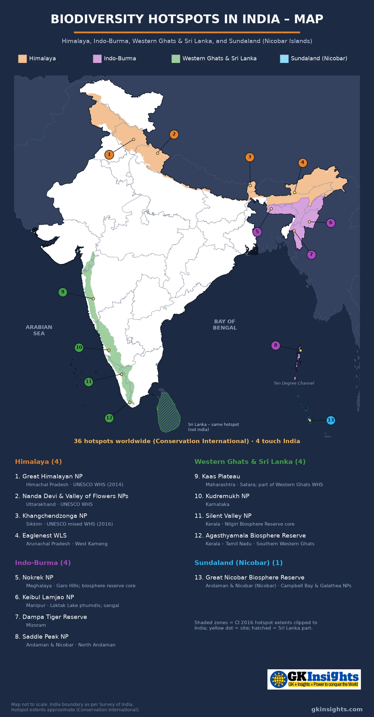
How to Read the Biodiversity Hotspots in India Map
Each coloured zone on the biodiversity hotspots in India map is one hotspot. The numbered markers are example national parks, sanctuaries and reserves that sit inside that zone:
- Himalaya (1–4) – the Himalayan arc from Jammu and Kashmir and Himachal Pradesh through Uttarakhand, Sikkim and the Darjeeling hills to Arunachal Pradesh
- Indo-Burma (5–8) – the hills of north-east India south and east of the Brahmaputra (Meghalaya, Nagaland, Manipur, Mizoram, most of Tripura and the hills of southern Assam), plus the Andaman Islands
- Western Ghats and Sri Lanka (9–12) – the narrow Western Ghats strip from the Tapi in the north to Kanyakumari in the south; Sri Lanka is the other half of the same hotspot
- Sundaland (13) – only the Nicobar Islands in India; the rest of the hotspot is the Malay Peninsula, Sumatra, Java, Borneo and nearby islands
A hotspot is a region, not a single park, so read the colours first and the numbers second. The markers are examples, not a complete list. For the parks themselves, use the national parks in India map and the biosphere reserves in India map together with this biodiversity hotspots in India map.
Some small Andaman and Nicobar coastal or island slivers are left unshaded because the Conservation International coastline does not match the Survey of India outline exactly.
What Is a Biodiversity Hotspot?
A biodiversity hotspot is a region that is both very rich in species found nowhere else and under heavy threat. The idea came from the British ecologist Norman Myers, who in 1988 named ten tropical forest regions that held many unique plants and were losing forest fast. Conservation International (CI) adopted the idea and, with Myers, set the formal criteria in a paper in Nature in 2000.
According to the Critical Ecosystem Partnership Fund (CEPF) hotspot definition, a region must meet both of these conditions:
- Endemism: at least 1,500 species of vascular plants that are found nowhere else on Earth (endemic). This is more than 0.5% of the world’s plant species.
- Threat: it must have lost at least 70% of its original (primary) native vegetation, so 30% or less is left.
Both conditions use plants and habitat, not animals. A region with many endemic animals but fewer than 1,500 endemic plants does not qualify. A region that is rich but still largely intact (such as much of the Amazon) is also not a hotspot. This is a common exam point.
How the Number Grew: 10, 25, 34, 36
| Year | Count | What happened |
|---|---|---|
| 1988 | 10 | Norman Myers names ten tropical forest hotspots |
| 2000 | 25 | Myers, Mittermeier and others publish the 25 hotspots and the two criteria in Nature |
| 2004–05 | 34 | CI reappraisal (“Hotspots Revisited”); the Himalaya is separated from Indo-Burma as its own hotspot |
| 2011 | 35 | Forests of East Australia added |
| 2016 | 36 | North American Coastal Plain recognised as the 36th hotspot (CEPF) |
NCERT Class 12 Biology, written when there were 34 hotspots, says three of them cover India’s richest regions: the Western Ghats and Sri Lanka, Indo-Burma and the Himalaya. Current Government of India statements count four of the 36, because the Nicobar Islands fall in Sundaland. For the exam, know both figures and say which source you are using.
Conservation International says the 36 hotspots together cover only about 2.5% of the Earth’s land surface. NCERT, using the older list, says “less than 2 per cent”. Both describe the same fact: a small share of land holds a very large share of the world’s endemic plants and animals.
Why There Are Four Biodiversity Hotspots in India
A Ministry of Environment press release (PIB, 2025) sums up India’s place: India is one of the world’s 17 megadiverse countries and home to four of the 36 global biodiversity hotspots – the Himalayas, the Western Ghats, Indo-Burma and Sundaland. India has only about 2.4% of the world’s land area but nearly 8% of global flora and 7.5% of global fauna, and about 28% of its plants and over 30% of its animals are endemic.
The reason lies in position and relief. India sits where three great biological realms meet – the Palaearctic (temperate Eurasia, reached through the Himalaya), the Afro-tropical and the Indo-Malayan. High mountains, very wet slopes facing the south-west monsoon, and long-isolated islands all produce species that occur nowhere else. All four biodiversity hotspots in India are in hills or islands (with the Terai and Assam valley at the foot of the Himalaya), not on the main plains. The central Indo-Gangetic plain, the Thar Desert, the Deccan interior and the Eastern Ghats are not part of any hotspot.
A large part of each hotspot lies outside India. The Himalaya hotspot runs into Pakistan, Nepal, Bhutan, China and Myanmar. Indo-Burma covers most of mainland South-East Asia. The Western Ghats share their hotspot with Sri Lanka. Sundaland is mostly Malaysia and Indonesia. So each of the biodiversity hotspots in India is one part of a larger, cross-border region.
Himalaya Biodiversity Hotspot on the Map (1–4)
The Himalaya biodiversity hotspot is the youngest and highest mountain system on Earth. CEPF describes it as an arc across northern Pakistan, Nepal, Bhutan, the north-western and north-eastern states of India, and the south-west China border. Until 2004 the eastern Himalaya was counted inside Indo-Burma; the reappraisal of that year made the Himalaya a separate hotspot.
In India it covers the forested Himalaya of Jammu and Kashmir, Himachal Pradesh, Uttarakhand, Sikkim, the Darjeeling hills of West Bengal and Arunachal Pradesh. On the CI boundary map, the Terai strip at the foot of the hills (Dudhwa, Valmiki, Jaldapara) and the Brahmaputra valley of Assam (with parks such as Kaziranga and Manas) are drawn inside the Himalaya hotspot, while the high cold desert of Ladakh lies mostly outside it. Keep this in mind if a map question shows Ladakh.
| No. | Example site | State / UT | What it is | Notes for exams |
|---|---|---|---|---|
| 1 | Great Himalayan National Park | Himachal Pradesh (Kullu) | National park | UNESCO World Heritage Site (2014); western Himalayan forests and alpine meadows |
| 2 | Nanda Devi and Valley of Flowers National Parks | Uttarakhand (Chamoli) | Two national parks, one WHS | UNESCO World Heritage Site (1988, extended 2005); alpine flowers, snow leopard habitat |
| 3 | Khangchendzonga National Park | Sikkim | National park / biosphere reserve core | India’s first “mixed” (natural + cultural) World Heritage Site (2016) |
| 4 | Eaglenest Wildlife Sanctuary | Arunachal Pradesh (West Kameng) | Wildlife sanctuary | Eastern Himalayan bird area; the Bugun liocichla was described from here in 2006 |
Key Species and Features of the Himalaya Hotspot
The Himalaya hotspot changes sharply with height – from subtropical broadleaf forest in the foothills, through oak and rhododendron forest and conifers, to alpine meadows. Typical species include the red panda, snow leopard, Himalayan tahr, takin (Arunachal), the hangul or Kashmir stag (Dachigam), the Himalayan monal and many rhododendrons and orchids. CEPF also notes important tiger and Asian elephant populations in the foothills, and the white-winged duck of the eastern wet forests.
Main threats are forest loss for farming and fuelwood, roads and hydropower projects in narrow valleys, grazing pressure in the alpine zone and climate change in the high mountains. Use the mountains and ranges of India post to place the Himalayan ranges themselves.
Indo-Burma Biodiversity Hotspot on the Map (5–8)
The Indo-Burma biodiversity hotspot covers about 2.37 million km² of tropical Asia east of the Ganga–Brahmaputra lowlands. CEPF says it includes all non-marine parts of Cambodia, Lao PDR, Myanmar, Thailand and Vietnam plus parts of southern China, and that it has more people (over 300 million) than any other hotspot. Its Indian part begins in north-east India south of the Brahmaputra. Among the biodiversity hotspots in India, it is the one that links the country most closely with South-East Asia.
In India the Indo-Burma part covers the hill states of Meghalaya, Nagaland, Manipur and Mizoram, most of Tripura and the hills of southern Assam. It also includes the Andaman Islands, which are biologically closer to Myanmar than to mainland India. This is why the Andaman marker (8) has the Indo-Burma colour on the biodiversity hotspots in India map.
| No. | Example site | State / UT | What it is | Notes for exams |
|---|---|---|---|---|
| 5 | Nokrek National Park | Meghalaya (Garo Hills) | National park; core of Nokrek Biosphere Reserve | Home of wild citrus (Citrus indica); biosphere reserve in UNESCO’s MAB network |
| 6 | Keibul Lamjao National Park | Manipur (Bishnupur) | National park on Loktak Lake | Floating park on phumdis (floating mats of vegetation); last natural home of the sangai (brow-antlered deer) |
| 7 | Dampa Tiger Reserve | Mizoram (Mamit) | Tiger reserve | Tropical evergreen and semi-evergreen hill forest on Mizoram’s western border with Bangladesh |
| 8 | Saddle Peak National Park | Andaman & Nicobar (North Andaman) | National park | Saddle Peak is the highest point of the Andaman and Nicobar Islands; Andaman = Indo-Burma, not Sundaland |
Key Species and Features of the Indo-Burma Hotspot
The north-east hills have tropical wet evergreen and semi-evergreen forests, bamboo brakes and pine forest at height. Typical species include the hoolock gibbon (India’s only ape), sangai (Manipur’s brow-antlered deer), clouded leopard, stump-tailed macaque, many hornbills and pitcher plants (Nepenthes khasiana of Meghalaya). The Andaman Islands add their own island species, such as the Andaman wild pig and the Narcondam hornbill.
Shifting cultivation (jhum) on short cycles, logging, hunting and road building are the main pressures. Many forests in the north-east are community-owned rather than state-owned, so village and clan reserves and sacred groves (for example in the Khasi and Jaintia Hills) matter for conservation.
Western Ghats Biodiversity Hotspot on the Map (9–12)
The Western Ghats biodiversity hotspot is formally called the Western Ghats and Sri Lanka hotspot. In India it is a narrow chain of hills about 1,600 km long along the western edge of the Deccan Plateau, from the Tapi river area in the north to Kanyakumari in the south, through Gujarat, Maharashtra, Goa, Karnataka, Kerala and Tamil Nadu. On the CI boundary the Indian part starts near the Dangs of south Gujarat.
CEPF notes that the Western Ghats cover less than 6% of India’s land area but hold more than 30% of all plant, fish, reptile and amphibian, bird and mammal species found in India. The heavy south-west monsoon on the windward slopes and the old, stable hills explain the very high endemism, especially of amphibians, reptiles, freshwater fish and flowering plants. In 2012 UNESCO listed a serial Western Ghats World Heritage Site made of 39 component sites in Kerala, Karnataka, Tamil Nadu and Maharashtra.
| No. | Example site | State / UT | What it is | Notes for exams |
|---|---|---|---|---|
| 9 | Kaas Plateau | Maharashtra (Satara) | Lateritic plateau; part of the Western Ghats WHS | Mass of seasonal wildflowers after the monsoon; many endemic small plants |
| 10 | Kudremukh National Park | Karnataka | National park | Shola forest and grassland; source area of the Tunga and Bhadra rivers; former iron-ore mining area |
| 11 | Silent Valley National Park | Kerala (Palakkad) | National park; core of Nilgiri Biosphere Reserve | Saved from a hydroelectric dam in the 1980s; lion-tailed macaque habitat; Kunthipuzha river |
| 12 | Agasthyamala Biosphere Reserve | Kerala – Tamil Nadu | Biosphere reserve (UNESCO MAB) | Southern end of the Ghats; includes Kalakad–Mundanthurai Tiger Reserve and Neyyar and Peppara sanctuaries |
Key Species and Features of the Western Ghats Hotspot
Typical endemic animals are the lion-tailed macaque, Nilgiri tahr (state animal of Tamil Nadu), Nilgiri marten, Malabar large-spotted civet, the purple frog and the Malabar gliding frog. The Ghats also hold the shola–grassland mosaic of the high hills, Myristica swamps and the Nilgiri Biosphere Reserve, India’s first biosphere reserve (1986).
Of all the biodiversity hotspots in India, the Western Ghats are the one most often asked about in Prelims, because they lie wholly in the peninsula and carry a UNESCO listing.
Sri Lanka is the other part of this hotspot. Its wet south-west and central hills share many plant and animal groups with the southern Western Ghats because the two were joined by land when sea levels were lower. On the map, Sri Lanka is shown only as a neighbour; it is not Indian territory.
Main threats are plantations (tea, coffee, rubber), dams, mining, roads and townships on the slopes. Two expert reports, by the Madhav Gadgil panel (2011) and the Kasturirangan working group (2013), proposed ecologically sensitive zones in the Ghats; their recommendations are still debated. Place the hills themselves with the plateaus of India map.
Sundaland Hotspot in India: Nicobar Islands (13)
The Sundaland hotspot covers the western half of the Indo-Malayan archipelago – Borneo, Sumatra, Java and nearby islands – plus a small part of southern Thailand, nearly all of Malaysia, Singapore and Brunei. The CEPF Sundaland page states that the Nicobar Islands, under Indian jurisdiction, are also included. It notes about 25,000 species of vascular plants in the hotspot, about 60% of them endemic.
India’s share is the smallest in area among the biodiversity hotspots in India, but it is distinctive. The Nicobar Islands lie south of the Ten Degree Channel, which separates them from the Andaman Islands. Use the straits near India map and the islands of India map to place the channel. The islands carry tropical evergreen forest, mangroves and coral reefs (see the coral reefs in India map).
| No. | Example site | State / UT | What it is | Notes for exams |
|---|---|---|---|---|
| 13 | Great Nicobar Biosphere Reserve | Andaman & Nicobar (Nicobar district) | Biosphere reserve (UNESCO MAB); includes Campbell Bay and Galathea National Parks | Indira Point, India’s southernmost point, is at its southern tip; Nicobar megapode; leatherback turtle nesting beaches; home of the Shompen |
Key Species and Features of the Nicobar Part of Sundaland
Typical Nicobar species include the Nicobar megapode (a mound-nesting bird), the Nicobar tree shrew, the Nicobar long-tailed macaque, the Nicobar pigeon and the giant robber crab. The beaches of Great Nicobar are important nesting sites for the leatherback turtle. The 2004 tsunami changed parts of the Nicobar coast, and large development plans for Great Nicobar have made its forests and coasts a subject of current debate.
Biodiversity Hotspots in India: Quick Comparison
Use this table with the biodiversity hotspots in India map for last-minute revision. Numbers match the map.
| Hotspot | Map nos. | Indian part | Shared with | Typical species |
|---|---|---|---|---|
| Himalaya | 1–4 | J&K, Himachal, Uttarakhand, Sikkim, Darjeeling hills, Arunachal (and the Assam valley on the CI map) | Pakistan, Nepal, Bhutan, China, Myanmar | Red panda, snow leopard, Himalayan tahr, takin, hangul, Himalayan monal |
| Indo-Burma | 5–8 | NE hills south / east of the Brahmaputra (Meghalaya, Nagaland, Manipur, Mizoram, Tripura, southern Assam) + Andaman Islands | Bangladesh (east), Myanmar, Thailand, Laos, Cambodia, Vietnam, southern China | Hoolock gibbon, sangai, clouded leopard, hornbills, pitcher plant |
| Western Ghats and Sri Lanka | 9–12 | Western Ghats: Gujarat, Maharashtra, Goa, Karnataka, Kerala, Tamil Nadu | Sri Lanka | Lion-tailed macaque, Nilgiri tahr, purple frog, Malabar civet |
| Sundaland | 13 | Nicobar Islands only | Malaysia, Indonesia, Singapore, Brunei, southern Thailand | Nicobar megapode, Nicobar tree shrew, leatherback turtle (nesting) |
Hotspots and Other Protected-Area Labels
A biodiversity hotspot is a global priority map made by scientists and conservation groups. It is not a legal category under Indian law, and no hotspot is “notified” by the Government of India. Do not confuse it with these labels:
| Label | Who gives it | Legal effect in India | Example |
|---|---|---|---|
| Biodiversity hotspot | Conservation International / scientists (Myers criteria) | None by itself; used for priority-setting and funding (e.g. CEPF) | Western Ghats and Sri Lanka |
| National park / wildlife sanctuary | State / Central Government under the Wild Life (Protection) Act, 1972 | Yes – legal protection | Silent Valley NP (11) |
| Tiger reserve | Government of India on NTCA advice | Yes – under the WLPA | Dampa Tiger Reserve (7) |
| Biosphere reserve | Government of India; some also in UNESCO’s MAB network | Administrative (core zone is usually a legal PA) | Great Nicobar (13), Agasthyamala (12) |
| World Heritage Site | UNESCO World Heritage Committee | International listing; protection is through national law | Western Ghats (9), Khangchendzonga (3) |
| Ramsar site | Ramsar Convention list | International listing for wetlands | Loktak Lake (around 6) |
One place can carry several labels at once. Keibul Lamjao (6) is a national park inside Loktak Lake, which is a Ramsar site, and both lie in the Indo-Burma hotspot. See also the wildlife sanctuaries in India map, tiger reserves in India and Ramsar sites in India.
Conservation of Biodiversity Hotspots in India
Because a hotspot has no legal status of its own, protection of the biodiversity hotspots in India depends on the laws and programmes that apply inside them:
- Protected areas – national parks, wildlife sanctuaries, conservation reserves and community reserves under the Wild Life (Protection) Act, 1972.
- Biosphere reserves – such as Nilgiri, Agasthyamala, Nokrek, Khangchendzonga and Great Nicobar, several of which are in UNESCO’s Man and the Biosphere network.
- Biological Diversity Act, 2002 – the National Biodiversity Authority, State Biodiversity Boards and local Biodiversity Management Committees, with People’s Biodiversity Registers.
- Forest and coastal rules – the forest conservation law, eco-sensitive zones around protected areas, and Coastal Regulation Zone rules for the island hotspots.
- Funding and research – CEPF has funded civil-society projects in the Western Ghats and the Eastern Himalayas; the Botanical Survey of India and Zoological Survey of India document species and are preparing a National Red List.
In the exam, link each hotspot to two or three protected areas from the map. That shows you know both the region and the legal tools that protect it.
Exam Traps on the Biodiversity Hotspots in India Map
These are the mix-ups that cost marks. Check each against the numbered biodiversity hotspots in India map.
- 34 or 36: NCERT (older list) says 34 hotspots worldwide and three covering India. Conservation International now lists 36, and the Government of India says India has four of them. If a question gives 36 as the total, the Indian count is four.
- Andaman vs Nicobar: the Andaman Islands are in Indo-Burma; the Nicobar Islands are in Sundaland. The Ten Degree Channel is the rough divide. Do not put the whole A&N group in one hotspot.
- Eastern Ghats: not a hotspot. Only the Western Ghats (with Sri Lanka) form a hotspot in peninsular India.
- “Eastern Himalaya” vs “Himalaya”: older books name the Eastern Himalaya. Since the 2004 reappraisal the hotspot is the whole Himalaya, including the western Himalaya of J&K, Himachal and Uttarakhand.
- Both criteria together: at least 1,500 endemic vascular plants and at least 70% of original vegetation lost. High animal endemism alone does not qualify a region.
- Who designates: Conservation International (with Myers’ criteria), not IUCN, UNESCO or the MoEFCC.
- Not a legal label: a hotspot is not a national park, sanctuary or biosphere reserve. Laws apply to the protected areas inside it.
- 17 vs 12 megadiverse: the Government of India uses “17 megadiverse countries”. NCERT Class 12 uses an older figure of 12. Both appear in exams.
- Shared hotspots: every hotspot touching India extends into other countries. Sri Lanka is part of the Western Ghats hotspot, not a separate one.
- Ladakh: Ladakh’s cold desert is mostly outside the Himalaya hotspot boundary on the CI map, even though Ladakh is a Himalayan region.
Site-wise Facts on Biodiversity Hotspots in India
Read these one-line facts along with the biodiversity hotspots in India map.
| Fact | Site / place |
|---|---|
| UNESCO WHS (2014), Kullu | Great Himalayan NP (1) |
| Two parks forming one WHS (1988 / 2005) | Nanda Devi and Valley of Flowers (2) |
| India’s first mixed World Heritage Site (2016) | Khangchendzonga NP (3) |
| Bugun liocichla described in 2006 | Eaglenest WLS (4) |
| Wild citrus gene pool, Garo Hills | Nokrek NP (5) |
| Floating national park; sangai | Keibul Lamjao NP (6) |
| Mizoram tiger reserve | Dampa (7) |
| Highest point of the A&N Islands | Saddle Peak NP (8) |
| Plateau of seasonal wildflowers, Satara | Kaas (9) |
| Source area of the Tunga and Bhadra | Kudremukh NP (10) |
| Saved from a dam; lion-tailed macaque | Silent Valley NP (11) |
| Southernmost biosphere reserve of the Ghats | Agasthyamala (12) |
| Indira Point; Nicobar megapode | Great Nicobar BR (13) |
UPSC Practice Points on Biodiversity Hotspots in India
Read these points along with the biodiversity hotspots in India map. They cover facts often asked in UPSC and State PSC papers.
- Biodiversity hotspots in India: Himalaya, Indo-Burma, Western Ghats and Sri Lanka, Sundaland (Nicobar Islands).
- Criteria: at least 1,500 endemic vascular plants and at least 70% of primary vegetation lost.
- Term from Norman Myers (1988); criteria formalised with Conservation International (2000); 36th hotspot added in 2016.
- Hotspots cover about 2.5% of Earth’s land (CI); NCERT’s older line is “less than 2 per cent”.
- India: 2.4% of world land, about 8% of flora and 7.5% of fauna; one of 17 megadiverse countries (MoEFCC / PIB).
- Western Ghats: less than 6% of India’s land, more than 30% of its species (CEPF); serial UNESCO WHS since 2012.
- Andaman Islands = Indo-Burma; Nicobar Islands = Sundaland.
- Example species: red panda (Himalaya), hoolock gibbon and sangai (Indo-Burma), lion-tailed macaque and Nilgiri tahr (Western Ghats), Nicobar megapode (Sundaland).
- Revise with the national parks in India map, biosphere reserves in India map, elephant reserves in India, mangrove sites in India map and natural vegetation of India.
FAQs on Biodiversity Hotspots in India Map
How many biodiversity hotspots are in India?
The biodiversity hotspots in India are four of the world’s 36: the Himalaya, Indo-Burma, the Western Ghats and Sri Lanka, and Sundaland (only the Nicobar Islands). Older NCERT text, based on the list of 34 hotspots, names three: the Western Ghats and Sri Lanka, Indo-Burma and the Himalaya.
What are the criteria for a biodiversity hotspot?
A region must have at least 1,500 species of vascular plants found nowhere else (endemic) and must have lost at least 70% of its original native vegetation. Both conditions must be met.
Who gave the concept of biodiversity hotspots?
The British ecologist Norman Myers introduced the idea in 1988. Conservation International adopted it, and Myers and colleagues set the present criteria in a 2000 paper in Nature.
Which hotspot do the Andaman and Nicobar Islands belong to?
They are split. The Andaman Islands fall in the Indo-Burma hotspot, and the Nicobar Islands fall in the Sundaland hotspot. The Ten Degree Channel lies roughly between the two groups.
Which states are in the Western Ghats biodiversity hotspot?
The Western Ghats run through Gujarat, Maharashtra, Goa, Karnataka, Kerala and Tamil Nadu. The hotspot is shared with Sri Lanka, so its full name is the Western Ghats and Sri Lanka hotspot.
Are the Eastern Ghats a biodiversity hotspot?
No. The Eastern Ghats are rich in species but are not one of the 36 hotspots. In peninsular India only the Western Ghats are part of a hotspot.
What do the numbers on the biodiversity hotspots in India map show?
They are 13 example protected areas: 1–4 in the Himalaya, 5–8 in Indo-Burma (8 is in the Andaman Islands), 9–12 in the Western Ghats and 13 (Great Nicobar) in Sundaland. They help you place each hotspot; they are not a full list of protected areas.
Also Check:
– National Parks in India Map
– Wildlife Sanctuaries in India Map
– Biosphere Reserves in India Map
– Coral Reefs in India Map
– Islands of India Map
– Straits and Channels Near India Map
– Mangrove Forest Sites in India Map
– UNESCO World Heritage Sites in India Map
– Tiger Reserves in India
– Ramsar Sites in India