
This post explains the coral reefs in India map with 16 numbered sites. It covers the four major reef areas – Gulf of Kutch (Gujarat), Gulf of Mannar and Palk Bay (Tamil Nadu), Lakshadweep atolls, and the Andaman–Nicobar Islands – plus two secondary west-coast patch sites (Malvan and Angria Bank). For each place you will learn the reef type, the protection status and the facts that matter for UPSC and State PSC.
Aspirants often mix up atolls with fringing reefs, or forget that India’s north-western reef area sits in the Gulf of Kutch. The Coral Reefs in India Map below keeps the same numbers as the tables. Read the map first, then the sections. Locations are approximate and the map is not to scale.
Coral Reefs in India Map
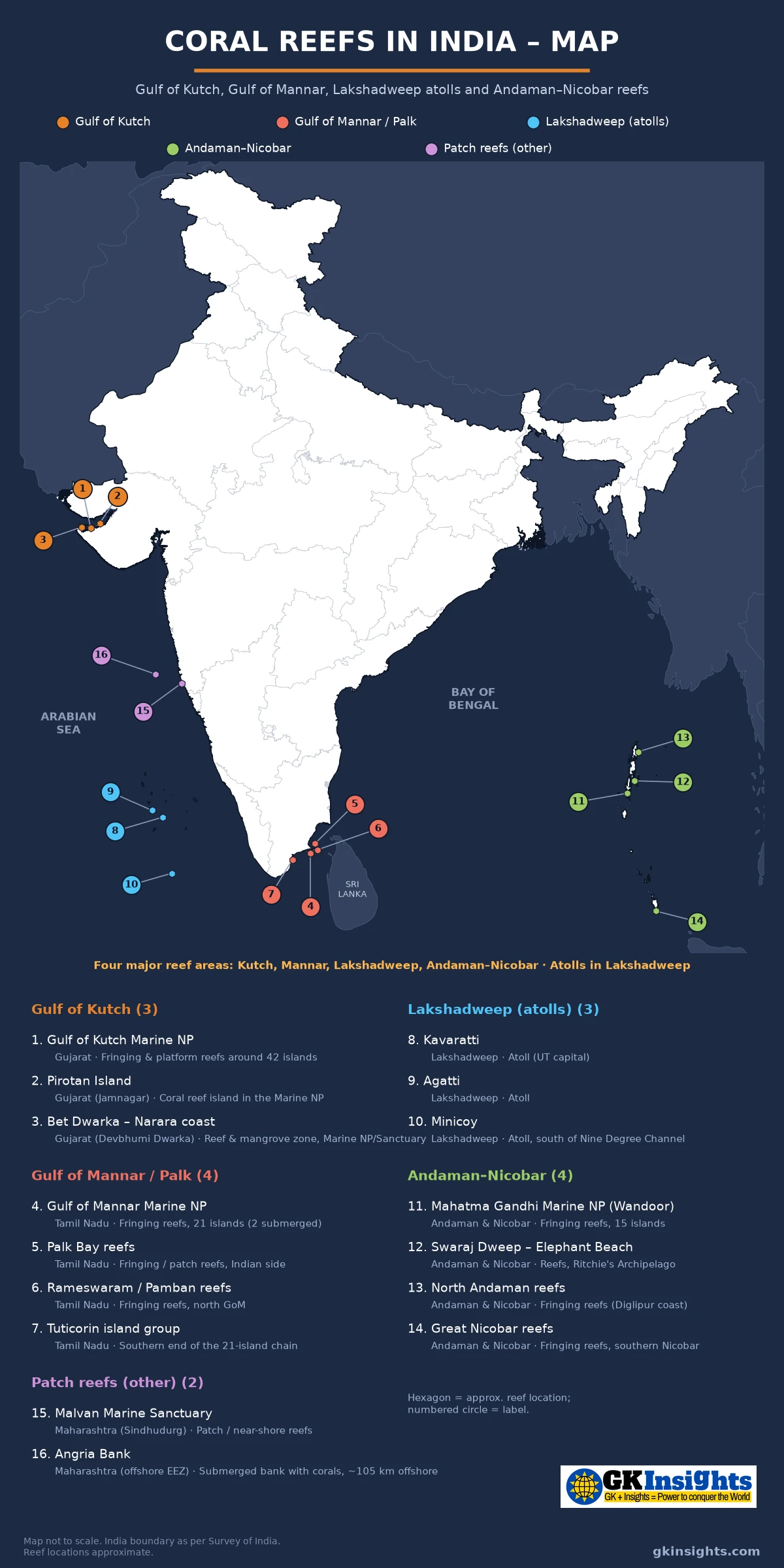
How to Read the Coral Reefs in India Map
Each site on the coral reefs in India map has a number and a colour. The colour shows its region:
- Gulf of Kutch (1–3) – Marine National Park / Sanctuary islands and coasts in Jamnagar and Devbhumi Dwarka (Gujarat); India’s north-western reef area; fringing / platform / patch
- Gulf of Mannar / Palk (4–7) – 21-island Marine National Park chain, Palk Bay, Rameswaram / Pamban and Tuticorin ends; mainly fringing and patch
- Lakshadweep atolls (8–10) – Kavaratti, Agatti and Minicoy; mainly coral atolls (Andrott is a platform reef)
- Andaman–Nicobar (11–14) – Mahatma Gandhi Marine National Park (Wandoor), Swaraj Dweep (Havelock), North Andaman / Diglipur and Great Nicobar; fringing and barrier
- Patch reefs – other west coast (15–16) – Malvan Marine Sanctuary and Angria Bank (Maharashtra); secondary sites, not a fifth equal “major” area
Reefs are coastal or island-fringe features, not inland points. On the coral reefs in India map each marker sits in water or on the reefed coast. Lakshadweep markers sit clearly west of Kerala. Gulf of Mannar markers sit between Tamil Nadu and Sri Lanka, south of Adam’s Bridge / Palk. Use the islands of India map and the straits near India map together with this coral reefs in India map when a question links islands, channels and reefs.
Why Coral Reefs Matter and What Types India Has
Coral reefs are among the most diverse shallow-marine ecosystems. They shelter fish and invertebrates, support coastal fisheries and tourism, and act as a breakwater that reduces wave energy along exposed shores. India’s mainland coast has only limited reef growth because of high nearshore turbidity and river runoff; most well-developed reefs sit around clearer island and gulf waters.
NCERT Class 11, India: Physical Environment, Chapter 2 states that the Arabian Sea island group – Lakshadweep and Minicoy – is built of coral deposits, with about 36 islands of which 11 are inhabited (NCERT’s count). NCERT Class 9, Contemporary India – I, Chapter 1 places the Andaman and Nicobar Islands to the south-east of the mainland and Lakshadweep to the south-west, and names the Palk Strait and the Gulf of Mannar as the narrow sea channel separating Sri Lanka from India. Those NCERT lines are the school-book base; the detailed four-area list comes from MoEF / Space Applications Centre material and standard geography books.
For Prelims, remember three reef types and how India uses them:
- Fringing reefs – grow close to the shore (mainland or island) and extend seaward like a submerged platform. Gulf of Mannar / Palk Bay reefs and many Andaman–Nicobar shores are of this type; the Andamans also have barrier reefs in places, and the Gulf of Kutch includes platform / patch reefs on sandstone.
- Atolls – roughly ring-shaped reefs surrounding a lagoon or low island. In India, Lakshadweep is the classic atoll archipelago (about 12 atolls on the Chagos–Laccadive ridge; Andrott is often listed as a platform reef rather than a classic atoll).
- Patch reefs – smaller, often isolated reef patches on the shelf or in a gulf. Palk Bay, parts of the Gulf of Kutch and west-coast sites such as Malvan / Angria Bank are often described this way.
A Ministry of Environment, Forest and Climate Change compilation on coral reefs in India names four major reef areas – Gulf of Mannar, Gulf of Kutch (Kachchh), Lakshadweep and Andaman & Nicobar – with a total mapped reef area of about 2,384 km² (SAC-based figures; Malvan’s tiny offshore patch is listed separately). The coral reefs in India map follows that four-area frame and adds Malvan and Angria Bank so you can spot mainland west-coast reefs without treating them as equal to the four.
Gulf of Kutch Coral Reefs on the Map (1–3)
The Gulf of Kutch coral reefs sit on Gujarat’s Jamnagar / Devbhumi Dwarka coast along the southern shore of the gulf. They form India’s north-western coral-reef area (often described in exam books as the country’s northernmost reefs; NASA Earth Observatory also calls them among the world’s most northerly) and grow under tough conditions – high salinity, large temperature swings, heavy sedimentation and extreme tides that can exceed 4 m. Most reefs here are fringing, platform or patch reefs on sandstone around a chain of islands.
| No. | Site | State / UT | Type / setting | Notes for exams |
|---|---|---|---|---|
| 1 | Gulf of Kutch Marine National Park | Gujarat | Fringing / patch on ~42 islands | India’s first Marine Sanctuary (1980) and first Marine National Park (1982); north-western reef province |
| 2 | Pirotan Island | Jamnagar district, Gujarat | Island reefs inside the Marine NP | Best-known coral-viewing island; boat access with forest permit |
| 3 | Bet Dwarka – Narara coast | Devbhumi Dwarka (Gujarat) | Mangrove + intertidal reef zone | Combined coast label; Narara near Vadinar; Bet Dwarka ~60 km west; low-tide reef walks |
Marine National Park, Pirotan and Narara
Gulf of Kutch Marine National Park (1) was built in two steps. In 1980 a stretch from Okha toward Jodiya was declared a Marine Sanctuary; in 1982 a core area became India’s first Marine National Park. The Marine National Park / Sanctuary complex (often managed with a Jamnagar forest office) covers about 42 islands along the southern gulf shore, most ringed by coral reefs, protecting both coral and mangrove ecosystems. Pirotan lies in Jamnagar district; Narara and Bet Dwarka lie in Devbhumi Dwarka district. Biodiversity is lower than in warmer, clearer reef provinces, but hard and soft corals, sponges, dugongs, sea turtles and large flocks of waterbirds are recorded.
Pirotan Island (2) is the park’s best-known coral-viewing island. Access is by permitted boat (often from Bedi / nearby ports), not by a routine public ferry. Bet Dwarka – Narara coast (3) is a combined label on the map: Narara (near Vadinar) is the usual low-tide reef-walk access; Bet Dwarka sits farther west in the same Devbhumi Dwarka district. Do not treat the two as one tiny spot, and do not confuse Narara’s road-and-tide visit with Pirotan’s boat day-trip. On the coral reefs in India map, numbers 1–3 sit in north-west India – that location answers many “northern / north-western reef” questions.
Link this section with the national parks of India map when a question asks for India’s first marine national park. Remember: first marine NP = Gulf of Kutch (1982), not Gulf of Mannar.
Gulf of Mannar Coral Reefs and Palk Bay on the Map (4–7)
The Gulf of Mannar coral reefs lie between south-east Tamil Nadu and Sri Lanka. NCERT Class 9 pairs the Gulf of Mannar with the Palk Strait as the narrow sea that separates Sri Lanka from India. On the Indian side a chain of 21 islands between Rameswaram / Pamban and Tuticorin (Thoothukudi) carries fringing and patch reefs. This is one of India’s richest marine areas, with seagrass beds and dugongs as well as coral.
| No. | Site | State / UT | Type / setting | Notes for exams |
|---|---|---|---|---|
| 4 | Gulf of Mannar Marine National Park | Tamil Nadu | Fringing / patch; 21 islands | Core of Gulf of Mannar Biosphere Reserve; Rameswaram–Tuticorin chain |
| 5 | Palk Bay reefs | Tamil Nadu side of Palk Bay | Patch / fringing | Plotted on the Indian (Tamil Nadu) side only; north of Adam’s Bridge; not the same water body as the Gulf of Mannar |
| 6 | Rameswaram / Pamban Island reefs | Northern GoM chain | Fringing / patch | Northern end of the 21-island park chain; near Adam’s Bridge |
| 7 | Tuticorin (Thoothukudi) southern GoM islands | Southern GoM chain | Fringing / patch | Southern end of the 21-island chain toward Tuticorin |
21 Islands, Biosphere Reserve and Palk Bay
Gulf of Mannar Marine National Park (4) covers 21 islands (two of which are now submerged after past coral mining / erosion) and their surrounding reefs. Standard MoEF / Tamil Nadu material treats the park as declared in 1986 and the wider Gulf of Mannar Biosphere Reserve as notified in 1989 – often called the first marine biosphere reserve in South / South-East Asia. The islands are commonly grouped as Mandapam, Keelakarai, Vembar and Tuticorin groups. Public access inside the core is tightly limited (glass-bottom boats in regulated zones).
Palk Bay reefs (5) sit on the shallower bay north of Adam’s Bridge. Keep Palk Bay distinct from the Gulf of Mannar: Adam’s Bridge (Rama Setu) is the shoal chain that divides them. The straits near India map numbers Palk Strait, Adam’s Bridge and the Gulf of Mannar in north-to-south order – use that order here too. Rameswaram / Pamban (6) marks the northern end of the Indian island chain; Tuticorin (7) marks the southern end. Exam trap: “21 islands” belongs to the Gulf of Mannar Marine National Park, not to Lakshadweep and not to the Gulf of Kutch’s ~42 islands.
Lakshadweep Atolls on the Coral Reefs in India Map (8–10)
Lakshadweep atolls are India’s classic coral-atoll group – about 12 atolls, with Andrott often listed separately as a platform reef. NCERT Class 11 places these islands roughly between 8°N–12°N and 71°E–74°E, about 220–440 km off the Kerala coast, and states that the entire group is built of coral deposits. Official and standard geography sources describe about 12 atolls, three reefs and five submerged banks, with roughly 36 islands / islets and a small total land area. On the coral reefs in India map the Lakshadweep markers sit clearly in the Arabian Sea west of Kerala.
| No. | Site | State / UT | Type / setting | Notes for exams |
|---|---|---|---|---|
| 8 | Kavaratti atoll | Lakshadweep UT | Classic atoll; capital island | Administrative headquarters of the UT |
| 9 | Agatti atoll | Lakshadweep UT | Atoll with airport island | Civil airport gateway to the territory |
| 10 | Minicoy atoll | Southern Lakshadweep | Atoll south of Nine Degree Channel | Separated from the main group by the Nine Degree Channel; Eight Degree Channel lies south toward the Maldives |
Kavaratti, Agatti and Minicoy
Kavaratti (8) is the capital atoll and a textbook example of a lagoon enclosed by a coral rim. Agatti (9) holds the territory’s airport, so many travel and map questions name it. Minicoy (10) lies south of the Nine Degree Channel; the Eight Degree Channel then separates Minicoy from the Maldives. That channel order is revised in detail on the straits near India map – for this coral reefs in India map, the exam hook is: Lakshadweep = mainly atolls; Mannar / Palk = fringing; Kutch = fringing / platform / patch; Andaman–Nicobar = fringing (and barrier in places).
Do not call every coral island an atoll. Andaman and Nicobar islands are largely the tops of a submerged mountain / volcanic arc with fringing reefs around them. Lakshadweep islands sit on coral rings built on the Chagos–Laccadive ridge. When a question asks “which Indian island group is of coral origin / atoll type?”, the safe answer is Lakshadweep.
Andaman and Nicobar Coral Reefs on the Map (11–14)
The Andaman Nicobar coral reefs are mainly fringing reefs around a long island arc in the Bay of Bengal, with barrier reefs also reported in official tourism / ZSI summaries. NCERT Class 11 divides the group into the Andaman in the north and the Nicobar in the south, separated by the Ten Degree Channel, and notes coral deposits along the coastal line of these islands. Space Applications Centre / MoEF compilations assign the largest share of India’s mapped reef area to this group. The coral reefs in India map picks four representative sites from north to south.
| No. | Site | State / UT | Type / setting | Notes for exams |
|---|---|---|---|---|
| 11 | Mahatma Gandhi Marine National Park (Wandoor) | South Andaman | Fringing reefs; multi-island park | Declared 1983; ~15 islands (A&N Forest); near Port Blair / Wandoor; Jolly Buoy / Red Skin |
| 12 | Swaraj Dweep (Havelock) / Elephant Beach reefs | Ritchie’s Archipelago | Fringing / nearshore reefs | Popular dive and snorkel reefs east of South Andaman |
| 13 | North Andaman / Diglipur coast reefs | North Andaman | Fringing reefs | Representative North Andaman location; not a confirmed named official site |
| 14 | Great Nicobar reefs | Southern Nicobar | Fringing reefs near Indira Point | Southern tip of India’s island chain; toward the Great Channel / Sumatra approach |
Wandoor, Havelock, Diglipur and Great Nicobar
Mahatma Gandhi Marine National Park (11), often called the Wandoor Marine National Park, was created on 24 May 1983 to protect corals and nesting sea turtles. It lies about 20 km south-west of Port Blair and includes a cluster of uninhabited islands and rocks (commonly cited as about 15–20 islands / islets, including well-known visitor sites such as Jolly Buoy and Red Skin). Most reefs inside the park are fringing reefs.
Swaraj Dweep (Havelock) (12), in Ritchie’s Archipelago, is famous for clear-water fringing reefs at places such as Elephant Beach. North Andaman / Diglipur (13) is a representative marker for northern Andaman reef coasts (the Diglipur coast is not a confirmed site-level official name). Great Nicobar (14) carries fringing reefs near India’s southern tip at Indira Point – useful when a map question links the southernmost land point with nearby coral and the approach toward the Strait of Malacca (see the straits near India map).
Exam caution: Andaman–Nicobar reefs are extensive, but the island group itself is not an atoll chain. Keep the word “atoll” for Lakshadweep on the coral reefs in India map; do not call Andaman–Nicobar an atoll chain.
Patch Reefs on the West Coast: Malvan and Angria Bank (15–16)
Besides the four major areas, standard books and MoEF / INCOIS material also mention smaller patch or offshore reefs on the mainland west coast. On the coral reefs in India map these are numbered 15–16 so you can recognise them – they are not a fifth equal major province.
| No. | Site | State / UT | Type / setting | Notes for exams |
|---|---|---|---|---|
| 15 | Malvan Marine Sanctuary | Maharashtra (Sindhudurg) | Offshore fringing / patch reefs | Small mapped reef area; listed by MoEF / INCOIS with the major sites |
| 16 | Angria Bank | Offshore Maharashtra (west of Vijaydurg) | Submerged bank with platform reef | ~100–105 km west of Vijaydurg; submerged bank with coral; designated-area proposal only |
Why These Two Appear in Books
Malvan Marine Sanctuary (15) protects a stretch of Sindhudurg coast and nearshore waters that include patchy coral. MoEF / SAC figures give only a fraction of a square kilometre of mapped reef here – tiny next to Lakshadweep or the Andamans, but enough for exam books and INCOIS maps to name Malvan beside the four majors.
Angria Bank (16) is a submerged bank on the continental shelf about 100–105 km west of Vijaydurg. It is a platform-type coral reef on a shallow sunken feature (depths often tens of metres, with much deeper water around the flanks), not a tourist beach reef. Maharashtra approved a proposal (around 2020, per news reports) to seek a designated marine area for the bank; do not call Angria Bank a notified national park or sanctuary until a final central notification exists. Stick to the geography for Prelims. Netrani (Karnataka) and a few other mainland patches appear in some lists – they are not numbered on this coral reefs in India map to avoid crowding.
Threats and Conservation (Factual Notes for Exams)
Indian reefs face both natural and human pressures. Know the main headings; do not turn this into a campaign essay in the exam hall.
- Coral bleaching – prolonged high sea-surface temperature can expel symbiotic algae (zooxanthellae), turning colonies white and risking mortality. Mass bleaching years are a recurring current-affairs hook for all four major areas.
- Sedimentation and turbidity – especially severe in the Gulf of Kutch; also linked to coastal works, dredging and river runoff on mainland coasts.
- Destructive fishing and coral mining – historically serious in parts of the Gulf of Mannar (some islands eroded or submerged after excessive mining). Anchoring and bottom gear damage fringing reefs.
- Coastal development, ports and pollution – industries, shipping and untreated waste raise stress on nearshore reefs.
- CRZ and Wildlife Protection – coral reefs fall under Coastal Regulation Zone protection (CRZ-I in the classic 1991 framework; later CRZ notifications continue to treat ecologically sensitive marine areas strictly). Reefs inside sanctuaries and national parks come under the Wildlife (Protection) Act.
- Marine protected areas – Gulf of Kutch Marine NP / Sanctuary; Gulf of Mannar Marine NP and Biosphere Reserve; Mahatma Gandhi Marine NP (Wandoor); Malvan Marine Sanctuary; plus island-wise regulations in Lakshadweep and broader A&N forest / coastal rules.
INCOIS (Ministry of Earth Sciences) maps coral eco-morphology and runs bleaching-alert related services. MoEF’s mangrove and coral schemes support on-ground work in the identified reef sites. For map questions, pair protection names with the correct state / UT on the coral reefs in India map rather than memorising every scheme year.
Quick Comparison: Four Major Areas vs Patch Sites
Use this table with the coral reefs in India map for last-minute revision. Numbers match the map.
| Area / site | Map nos. | Sea / coast | Dominant type | Key protection |
|---|---|---|---|---|
| Gulf of Kutch | 1–3 | Arabian Sea (Gujarat) | Fringing / platform / patch | Marine Sanctuary 1980; Marine NP 1982; ~42 islands |
| Gulf of Mannar / Palk | 4–7 | Bay of Bengal / Laccadive Sea side (TN) | Fringing / patch | Marine NP (21 islands, 2 submerged; 1986); Biosphere Reserve 1989 |
| Lakshadweep | 8–10 | Arabian Sea | Mainly atolls (~12; Andrott = platform) | Island / UT regulations; coral-built archipelago |
| Andaman–Nicobar | 11–14 | Bay of Bengal / Andaman Sea | Fringing (+ barrier in places) | MGMNP Wandoor 1983; other island parks / sanctuaries |
| Malvan (secondary) | 15 | Arabian Sea (Maharashtra) | Patch / offshore fringing | Malvan Marine Sanctuary |
| Angria Bank (secondary) | 16 | Offshore Arabian Sea | Submerged platform reef | Bank ~100–105 km west of Vijaydurg; designated-area proposal only – not a notified NP |
Exam Traps on the Coral Reefs in India Map
These are the swaps that cost marks. Check each against the numbered coral reefs in India map.
- Atoll vs fringing: Lakshadweep (8–10) is the atoll group (Andrott often listed as a platform reef). Mannar / Palk are fringing; Kutch has fringing / platform / patch; Andaman–Nicobar has fringing and some barrier reefs.
- North-western / “northernmost” exam phrasing: Gulf of Kutch (1–3), not Andaman and not Mannar. Soften to north-western if the question does not use that word.
- 21 islands: Gulf of Mannar Marine National Park (4), not Kutch’s ~42 islands and not Lakshadweep’s ~36 islands.
- First marine national park: Gulf of Kutch (1982), not Gulf of Mannar and not Wandoor.
- First marine biosphere reserve (India / South Asia framing): Gulf of Mannar Biosphere Reserve (1989).
- Palk Bay vs Gulf of Mannar: Adam’s Bridge divides them. Palk Bay is north; Gulf of Mannar is south.
- Minicoy as “mainland” reef: Minicoy (10) is a Lakshadweep atoll south of the Nine Degree Channel.
- Angria Bank as a beach: It is a submerged offshore bank, not a coastal tourist beach like Malvan’s shore.
- Andaman = atoll: Wrong. Andaman–Nicobar = fringing reefs (barrier reefs also reported) on a continental / volcanic island arc.
Site-wise Facts: Quick Revision from the Coral Reefs in India Map
Use this table with the coral reefs in India map for last-minute revision. Numbers match the map.
| Fact | Site / place |
|---|---|
| North-western Indian coral reefs (exam books: northernmost) | Gulf of Kutch (1–3) |
| India’s first Marine Sanctuary / first Marine NP | Gulf of Kutch – 1980 / 1982 (1) |
| Popular Kutch coral island | Pirotan (2) |
| Bet Dwarka – Narara coast (Devbhumi Dwarka) | Number 3 |
| 21 islands between Rameswaram and Tuticorin | Gulf of Mannar Marine NP (4) |
| Biosphere Reserve year (standard books) | Gulf of Mannar – 1989 |
| Reefs north of Adam’s Bridge | Palk Bay (5) |
| Mainly-atoll archipelago (Andrott = platform) | Lakshadweep (8–10) |
| Lakshadweep capital atoll | Kavaratti (8) |
| Lakshadweep airport island | Agatti (9) |
| Atoll south of Nine Degree Channel | Minicoy (10) |
| Wandoor Marine National Park (1983) | Mahatma Gandhi MNP (11) |
| Ritchie’s Archipelago dive reefs | Swaraj Dweep / Havelock (12) |
| Southern Nicobar fringing reefs | Great Nicobar (14) |
| Maharashtra marine sanctuary with patch reefs | Malvan (15) |
| Submerged bank reef west of Vijaydurg | Angria Bank (16) |
| MoEF four major areas + total reef area (SAC) | Mannar, Kutch, Lakshadweep, A&N; ~2,384 km² |
UPSC Practice Points on Coral Reefs in India Map
Read these points along with the coral reefs in India map. They cover facts often asked in UPSC and State PSC papers.
- Four major areas: Gulf of Kutch, Gulf of Mannar, Lakshadweep, Andaman–Nicobar.
- Lakshadweep = mainly atolls (Andrott = platform); Mannar/Palk fringing; Kutch fringing/platform/patch; A&N fringing (+ barrier); Malvan / Angria = secondary patch / offshore sites.
- NCERT: Lakshadweep built of coral deposits; Sri Lanka separated by Palk Strait and Gulf of Mannar.
- Gulf of Kutch: north-western reefs (exam books often say northernmost); Sanctuary 1980; Marine NP 1982; ~42 islands; Pirotan (Jamnagar) and Bet Dwarka–Narara (Devbhumi Dwarka).
- Gulf of Mannar: 21 islands (2 submerged); Marine NP 1986; Biosphere Reserve 1989; dugongs and seagrass.
- Lakshadweep: Kavaratti (capital), Agatti (airport), Minicoy (south of Nine Degree Channel).
- Andaman–Nicobar: MGMNP Wandoor 1983 (about 15 islands); Havelock / Diglipur (representative North Andaman coast) / Great Nicobar fringing reefs.
- Threats: bleaching, sedimentation, destructive fishing, mining, coastal pollution; CRZ + Wildlife Act protection.
- Revise with the islands of India map, straits near India map, national parks of India map, plateaus of India map, lakes of India map and rivers of India map.
FAQs on Coral Reefs in India Map
How many sites are shown on the coral reefs in India map?
The coral reefs in India map above shows 16 numbered sites: Gulf of Kutch (1–3), Gulf of Mannar / Palk (4–7), Lakshadweep atolls (8–10), Andaman–Nicobar (11–14) and secondary west-coast patch sites Malvan and Angria Bank (15–16).
What are the four major coral reef areas of India?
Standard MoEF material lists four major areas: the Gulf of Mannar, the Gulf of Kutch (Kachchh), Lakshadweep and the Andaman & Nicobar Islands. Together they account for about 2,384 km² of mapped reef area in SAC-based compilations. Malvan is a smaller offshore patch often listed beside them.
Which Indian reefs are atolls?
Lakshadweep (numbers 8–10 on the coral reefs in India map) is India’s classic coral-atoll archipelago (about 12 atolls; Andrott is often listed as a platform reef). Gulf of Mannar / Palk reefs are fringing; Gulf of Kutch has fringing, platform and patch reefs; Andaman–Nicobar has fringing and some barrier reefs.
Where are the northernmost coral reefs in India?
In the Gulf of Kutch, Gujarat (numbers 1–3) — India’s north-western reef area, often called the northernmost in exam books. India’s first Marine Sanctuary (1980) and first Marine National Park (1982) protect reefs and mangroves around about 42 islands, including Pirotan and the Bet Dwarka–Narara coast.
How many islands are in the Gulf of Mannar Marine National Park?
Twenty-one islands (two now submerged) between Rameswaram and Tuticorin form the Gulf of Mannar Marine National Park (number 4). The wider Gulf of Mannar Biosphere Reserve was notified in 1989.
Is the Andaman and Nicobar group an atoll chain?
No. Andaman–Nicobar reefs (11–14) are mainly fringing reefs (with barrier reefs also reported) around continental / volcanic islands. Atolls in India are characteristic of Lakshadweep.
What are Malvan and Angria Bank on the coral reefs in India map?
They are secondary west-coast sites (15–16). Malvan Marine Sanctuary in Sindhudurg, Maharashtra, has small offshore fringing / patch reefs. Angria Bank is a submerged coral bank about 100–105 km west of Vijaydurg (designated-area proposal only; not a notified NP/sanctuary). They are not treated as a fifth major area equal to Kutch, Mannar, Lakshadweep and Andaman–Nicobar.
Also Check:
– Islands of India Map
– Straits and Channels Near India Map
– National Parks in India Map
– Plateaus of India Map
– Lakes in India Map
– Major Dams in India Map
– UNESCO World Heritage Sites in India Map
– Rivers of India Map
– Minerals in India Map
– Hydro Power Plants in India Map
– Ashokan Edicts Map