
This post explains the straits near India map with 10 numbered waterways. It covers the India–Sri Lanka passages (Palk Strait, Adam’s Bridge and the Gulf of Mannar), the Andaman–Nicobar channels (Coco, Preparis, Duncan Passage, Ten Degree Channel and Great Channel), and the Lakshadweep channels (Nine Degree and Eight Degree). For each waterway you will learn what it separates, where it sits and the facts that matter for UPSC and State PSC.
Aspirants often mix up the degree channels and swap Palk Strait with the Gulf of Mannar. The Straits and Channels Near India Map below keeps the same numbers as the tables. Read the map first, then the sections. Locations are approximate and the map is not to scale.
Straits Near India Map
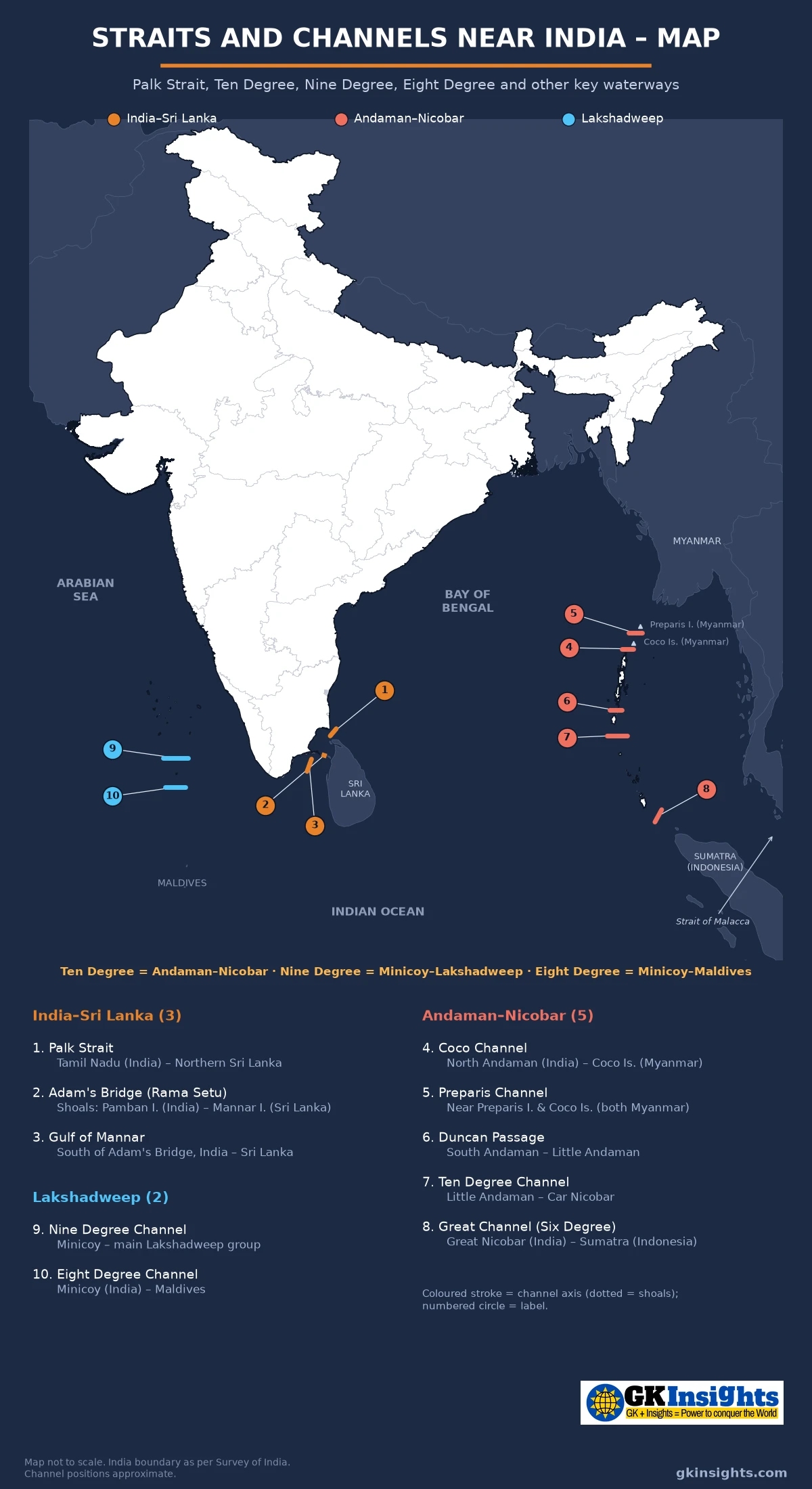
How to Read the Straits Near India Map
Each waterway on the straits near India map has a number and a colour. The colour shows its region:
- India–Sri Lanka (1–3) – Palk Strait, Adam’s Bridge (Rama Setu) and Gulf of Mannar
- Andaman–Nicobar (4–8) – Coco Channel, Preparis Channel, Duncan Passage, Ten Degree Channel and Great Channel (Six Degree Channel)
- Lakshadweep (9–10) – Nine Degree Channel and Eight Degree Channel
Channels are linear features, not point sites. On the straits near India map each one is a short stroke in the water between two landmasses, with a numbered circle at the midpoint. Adam’s Bridge is a chain of shoals, not a deep strait – exams still ask it with Palk Strait and the Gulf of Mannar. Far-away choke points such as Hormuz or Bab-el-Mandeb are not numbered here; the Strait of Malacca is covered only in the strategic notes as the south-east approach near the Great Channel.
Why These Waterways Matter
India’s mainland and island groups sit beside several short sea passages. Some separate India from a neighbour (Sri Lanka, Myanmar, Indonesia, Maldives). Others cut through India’s own island chains. NCERT Class 11, India: Physical Environment, Chapter 2 names the Ten Degree Channel between the Andaman and the Nicobar, and the Nine Degree Channel in Lakshadweep. NCERT Class 9, Contemporary India – I, Chapter 1 places the Andaman and Nicobar islands to the southeast of the mainland and Lakshadweep to the southwest.
Palk Strait, Duncan Passage, the Eight Degree Channel and the Great Channel are not listed in those NCERT paragraphs, but they appear constantly in map questions and standard geography books. Use the islands of India map together with this straits near India map when you revise both the land and the water between the islands.
India–Sri Lanka Waterways on the Straits Near India Map (1–3)
Between Tamil Nadu and northern Sri Lanka the sea is shallow and crowded with shoals. NCERT Class 9, Chapter 1 says Sri Lanka is separated from India by a narrow channel of sea formed by the Palk Strait and the Gulf of Mannar. Three related features appear again and again in Prelims: Palk Strait, Adam’s Bridge and the Gulf of Mannar. Keep them in north-to-south order on the straits near India map.
| No. | Waterway | Separates / location | Sea / bay | Notes for exams |
|---|---|---|---|---|
| 1 | Palk Strait | Tamil Nadu (India) and Northern Province / Jaffna (Sri Lanka) | Bay of Bengal (Palk Bay to the SW) | Shallow strait; NCERT Class 9 pairs it with Gulf of Mannar as the India–Sri Lanka separator; large ships usually go around Sri Lanka |
| 2 | Adam’s Bridge (Rama Setu) | Pamban Island (India) and Mannar Island (Sri Lanka) | Between Palk Bay and Gulf of Mannar | Chain of limestone shoals ~48 km long; sea often only 1–3 m deep over the banks |
| 3 | Gulf of Mannar | South of Adam’s Bridge, India (TN) and Sri Lanka | Opens to the Indian Ocean / Laccadive Sea | Gulf of Mannar Marine National Park (21 islands, 1986); Biosphere Reserve (1989); dugongs and coral reefs |
Palk Strait, Adam’s Bridge and the Gulf of Mannar
Palk Strait (1) lies between the south-east coast of India (around Point Calimere / the Tamil Nadu side) and the Jaffna peninsula of northern Sri Lanka. It opens to the Bay of Bengal; Palk Bay is the shallower embayment to its south-west, toward Adam’s Bridge. Do not treat the whole of Palk Bay as the strait. The water is relatively shallow – central parts of the strait are often around 20 m, with a maximum near 35 m – so big ocean-going ships prefer to sail south around Sri Lanka rather than cut through.
Adam’s Bridge (2), also called Rama Setu or Ram Setu, is the chain of limestone shoals and sandbanks that stretches about 48 km between Pamban Island (India) and Mannar Island (Sri Lanka). It separates Palk Bay / Palk Strait on the north from the Gulf of Mannar (3) on the south. Treat Adam’s Bridge as shoals, not as a deep navigable strait. Exams often ask which feature divides Palk Strait from the Gulf of Mannar – the answer is Adam’s Bridge.
The Gulf of Mannar opens southward toward the Indian Ocean. On the Indian side it holds the Gulf of Mannar Marine National Park (21 islands between Rameswaram and Tuticorin, declared in 1986) and the wider Gulf of Mannar Biosphere Reserve (1989). It is one of India’s richest marine areas, with coral reefs, seagrass beds and dugongs. Link this with the national parks of India map when marine parks appear in a question.
Pamban Island (Rameswaram) is linked to the Tamil Nadu mainland by the Pamban Bridge. Fishing communities on both the Indian and Sri Lankan sides of Palk Strait depend on these waters. India–Sri Lanka maritime boundary agreements (1974 and 1976) fixed the line in this area; fishermen’s arrests and the Katchatheevu islet remain recurring news topics. Know the geography first; the diplomacy follows from the map.
Andaman–Nicobar Channels on the Straits Near India Map (4–8)
East of the mainland, the Bay of Bengal island chain runs from Myanmar’s Coco and Preparis islands down through the Andaman Group and Nicobar Group toward Sumatra. NCERT Class 11 says the Andaman in the north and the Nicobar in the south are separated by the Ten Degree Channel. The other passages on this part of the straits near India map fill the gaps north and south of that NCERT line.
| No. | Waterway | Separates / location | Sea | Notes for exams |
|---|---|---|---|---|
| 4 | Coco Channel | North Andaman (Landfall Island, India) and Coco Islands (Myanmar) | Bay of Bengal / Andaman Sea | International channel; Coco Islands belong to Myanmar (Yangon Region) |
| 5 | Preparis Channel | Between Preparis Island and Coco Islands (both Myanmar) | Bay of Bengal / Andaman Sea | Both flanks are Myanmar; NOT the India–Myanmar boundary channel (that is Coco Channel); keep 4 and 5 distinct |
| 6 | Duncan Passage | South Andaman and Little Andaman | Andaman Sea / Bay of Bengal | Inside the Andaman Group; ~48 km wide; not a “degree” channel |
| 7 | Ten Degree Channel | Little Andaman (Andaman Group) and Car Nicobar (Nicobar Group) | Bay of Bengal / Andaman Sea | ~150 km wide at ~10°N; NCERT’s Andaman–Nicobar separator; most asked |
| 8 | Great Channel (Six Degree Channel) | Great Nicobar (Indira Point) and Sumatra (Indonesia) | Indian Ocean | Near Indira Point; southern approach toward the Strait of Malacca |
Coco, Preparis and Duncan Passage
Coco Channel (4) separates India’s northernmost Andaman land (Landfall Island / North Andaman) from Myanmar’s Coco Islands. The Coco Islands are part of Myanmar’s Yangon Region, even though they sit on the same island arc as the Andamans. The channel is only about 20 km wide – this is the India–Myanmar boundary channel on this part of the map. Preparis Channel (5) lies farther north, between Preparis Island and the Coco Islands. Both of those islands belong to Myanmar, so Preparis Channel is not an India–Myanmar boundary channel. On the straits near India map the two numbers sit close together – do not drop either, and do not treat them as the same waterway.
Duncan Passage (6) cuts inside the Andaman Group. It separates South Andaman (with Rutland Island at its southern edge) from Little Andaman. Exam books usually say “South Andaman and Little Andaman.” It is about 48 km wide. Remember: Duncan Passage is not the separator of Andaman from Nicobar – that job belongs to the Ten Degree Channel.
Ten Degree Channel (NCERT)
NCERT Class 11, Chapter 2 states that the entire Bay of Bengal island group is divided into two broad categories – the Andaman in the north and the Nicobar in the south – separated by a water body called the Ten Degree Channel. On the straits near India map this is number 7. It lies roughly along 10°N between Little Andaman and Car Nicobar and is about 150 km wide.
NCERT’s own exercise asks: “Which one of the water bodies separates the Andaman from the Nicobar?” Options include the 11° Channel, the Gulf of Mannar, the 10° Channel and the Andaman Sea. The expected answer is the 10° Channel. Do not pick Gulf of Mannar – that belongs to the India–Sri Lanka side of the straits near India map.
Great Channel and Indira Point
Great Channel (8), also called the Six Degree Channel in many exam books, lies between Great Nicobar and Sumatra (Indonesia). Some strategic notes give the gap from Indira Point to nearby Indonesian islands as about 160 km – treat that figure as approximate. Indira Point, the southernmost point of India, sits at the tip of Great Nicobar facing this water. NCERT Class 9 notes that Indira Point got submerged under sea water in the 2004 tsunami. Ships on the Colombo–Singapore route pass south of Indira Point on their way toward the Strait of Malacca. Mark Great Channel with number 8 on the straits near India map; do not confuse it with the Ten Degree Channel farther north.
Lakshadweep Channels on the Straits Near India Map (9–10)
West of Kerala, Lakshadweep is a coral archipelago in the Arabian Sea. NCERT Class 11 places these islands roughly between 8°N–12°N and 71°E–74°E, about 220–440 km off the Kerala coast. Two degree channels cut this area: Nine Degree and Eight Degree. Use the same numbers as the straits near India map.
| No. | Waterway | Separates / location | Sea | Notes for exams |
|---|---|---|---|---|
| 9 | Nine Degree Channel | Minicoy and the rest of Lakshadweep (Kalpeni / main group) | Arabian Sea | ~9°N; NCERT names this channel; see wording note below |
| 10 | Eight Degree Channel | Minicoy (India) and the Maldives | Arabian Sea / Laccadive Sea | ~8°N; international separator; also called Maliku Kandu in Dhivehi |
Nine Degree Channel – NCERT Wording and the Exam Map
NCERT Class 11 says the entire Lakshadweep group is broadly divided by the Nine Degree Channel, “north of which is the Amini Island and to the south of the Canannore Island.” That sentence is awkward. On standard exam maps and Admiralty charts, the Nine Degree Channel (9) lies at about 9°N between the main Lakshadweep / Laccadive group (including Kalpeni and Suheli Par) to the north and Minicoy to the south. Both the Amindivi (Amini) and Cannanore / Laccadive subgroups sit north of Minicoy; Minicoy alone lies south of the Nine Degree Channel.
How to handle this in answers: If the question quotes NCERT, state NCERT’s Amini / Cannanore wording. If the question asks what the Nine Degree Channel separates on a modern map, say Minicoy from the rest of Lakshadweep. The straits near India map follows the standard map reading (number 9 between the main group and Minicoy), the same way the islands of India map places Minicoy south of that channel. Width figures vary by source (about 180–200 km); the degree in the name is the safer exam hook.
Eight Degree Channel
Eight Degree Channel (10) lies at about 8°N between Minicoy (India) and the northern atolls of the Maldives. In Dhivehi it is also called Maliku Kandu. The India–Maldives maritime boundary runs through this channel. It is not named in the NCERT island paragraphs, but it is a favourite trap against the Nine Degree Channel. Order from north to south on the Arabian Sea side: main Lakshadweep → Nine Degree Channel → Minicoy → Eight Degree Channel → Maldives.
Quick Comparison: Ten vs Nine vs Eight Degree Channels
Degree channels are named after the parallel of latitude they roughly follow. Mixing them up is one of the most common map mistakes. Use this table with the straits near India map.
| Channel | Approx. latitude | Separates | Sea | NCERT? |
|---|---|---|---|---|
| Ten Degree Channel (7) | ~10°N | Andaman Group (Little Andaman) from Nicobar Group (Car Nicobar) | Bay of Bengal / Andaman Sea | Yes – Andaman vs Nicobar |
| Nine Degree Channel (9) | ~9°N | Main Lakshadweep / Kalpeni from Minicoy | Arabian Sea | Yes – wording about Amini / Cannanore; map puts Minicoy south |
| Eight Degree Channel (10) | ~8°N | Minicoy (India) from the Maldives | Arabian Sea | Not in the NCERT island paragraph |
| Great / Six Degree Channel (8) | ~6°N | Great Nicobar from Sumatra | Indian Ocean | Not in NCERT; Indira Point nearby |
A short north-to-south order that sticks: 10° = Andaman–Nicobar, 9° = Lakshadweep–Minicoy, 8° = Minicoy–Maldives, and (if asked) 6° = Great Nicobar–Sumatra. Duncan Passage has no degree name. Coco and Preparis sit north of the Andamans and are international, not degree channels.
Exam Traps on the Straits Near India Map
These are the swaps that cost marks. Check each against the numbered straits near India map.
- Palk Strait vs Gulf of Mannar: Palk is the northern strait toward the Bay of Bengal; the Gulf of Mannar is south of Adam’s Bridge. Adam’s Bridge divides them.
- Ten Degree vs Duncan Passage: Ten Degree separates Andaman from Nicobar. Duncan Passage separates South Andaman from Little Andaman inside the Andaman Group.
- Nine Degree vs Eight Degree: Nine = Minicoy from the rest of Lakshadweep. Eight = Minicoy from the Maldives. Both are in the Arabian Sea, not the Bay of Bengal.
- Ten Degree vs Nine Degree: Ten is Bay of Bengal (A&N). Nine is Arabian Sea (Lakshadweep). Same “degree” idea, different seas.
- Gulf of Mannar as Andaman–Nicobar separator: NCERT lists Gulf of Mannar as a wrong option in the Andaman–Nicobar question. Do not pick it.
- Adam’s Bridge as a deep strait: It is a chain of shoals. Large ships cannot safely cross it; that is why Sethusamudram was proposed.
- Coco Islands as Indian: Coco Islands belong to Myanmar. Coco Channel (4) is the India–Myanmar waterway.
- Preparis as India–Myanmar: Preparis Channel (5) sits between two Myanmar islands (Preparis and Coco). Do not call it the India–Myanmar boundary channel.
Strategic Notes: Malacca Approach, Sethusamudram and Palk Fisheries
The straits near India map also helps you see why these passages matter beyond map-pointing.
- Great Channel → Strait of Malacca: South of Indira Point, shipping heading toward South-East Asia enters the approach to the Strait of Malacca between Sumatra and the Malay Peninsula. Malacca is not numbered on this map (it sits farther south-east), but number 8 is the Indian end of that approach. India’s Andaman and Nicobar Command watches this eastern flank.
- Degree channels as sea lanes: The Ten, Nine and Eight Degree Channels carry a large share of east–west merchant traffic between the Gulf / Europe / Africa and East Asia. That is why questions link them to energy security and naval presence.
- Sethusamudram (briefly): The Sethusamudram Shipping Canal Project proposed a dredged channel so ships could pass between India’s east and west coasts without sailing around Sri Lanka. Alignments through or near Adam’s Bridge raised environmental, fisheries and cultural concerns. The project has not been completed. For Prelims, know why it was proposed (shallow Palk / Adam’s Bridge block) more than the engineering details.
- Palk fishermen: The shallow, productive waters of Palk Strait and Palk Bay support fishing on both sides. Cross-border arrests and the status of Katchatheevu appear in current-affairs questions; the map location (near numbers 1–2) is the geography you need first.
- Lakshadweep EEZ: Tiny coral islands push India’s Exclusive Economic Zone far into the Arabian Sea. Channels 9 and 10 sit inside that wider maritime space – useful when a question links islands, EEZ and sea lanes.
Site-wise Facts: Quick Revision from the Straits Near India Map
Use this table with the straits near India map for last-minute revision. Numbers match the map.
| Fact | Waterway / place |
|---|---|
| Separates India (TN) from Sri Lanka | Palk Strait (1) |
| Shoals between Pamban and Mannar | Adam’s Bridge / Rama Setu (2) |
| Divides Palk Bay from Gulf of Mannar | Adam’s Bridge (2) |
| Marine National Park with 21 islands | Gulf of Mannar (3) |
| India–Myanmar channel north of Andaman | Coco Channel (4) |
| Near Preparis / Coco, north of Andaman | Preparis Channel (5) |
| South Andaman vs Little Andaman | Duncan Passage (6) |
| Andaman Group vs Nicobar Group (NCERT) | Ten Degree Channel (7) |
| Width of Ten Degree Channel | About 150 km |
| Great Nicobar vs Sumatra | Great Channel / Six Degree Channel (8) |
| Southernmost point of India (nearby) | Indira Point, Great Nicobar |
| Main Lakshadweep vs Minicoy | Nine Degree Channel (9) |
| Minicoy vs Maldives | Eight Degree Channel (10) |
| NCERT exercise: Andaman from Nicobar | 10° Channel (not Gulf of Mannar) |
UPSC Practice Points on Straits Near India Map
Read these points along with the straits near India map. They cover facts often asked in UPSC and State PSC papers.
- India–Sri Lanka: Palk Strait (1), Adam’s Bridge (2), Gulf of Mannar (3) – north to south.
- Adam’s Bridge is limestone shoals ~48 km long; it is not a deep shipping strait.
- Gulf of Mannar Marine National Park (21 islands, 1986); Biosphere Reserve (1989).
- Coco Channel (4): North Andaman / Myanmar Coco Islands (India–Myanmar). Preparis Channel (5): between Preparis and Coco Islands (both Myanmar).
- Duncan Passage (6): South Andaman and Little Andaman – inside the Andaman Group.
- Ten Degree Channel (7): Little Andaman and Car Nicobar; ~150 km; NCERT’s Andaman–Nicobar separator.
- Great Channel / Six Degree Channel (8): Great Nicobar and Sumatra; near Indira Point; approach to Malacca.
- Nine Degree Channel (9): Minicoy and the rest of Lakshadweep; NCERT names it (see Amini / Cannanore wording note).
- Eight Degree Channel (10): Minicoy and the Maldives.
- Order of degree channels north to south: 10° (A&N) → 9° (Lakshadweep–Minicoy) → 8° (Minicoy–Maldives) → 6° (Great Nicobar–Sumatra).
- Sethusamudram: proposed dredged canal through the shallow Palk / Adam’s Bridge zone; not completed.
- Revise with the islands of India map, plateaus of India map, lakes of India map and rivers of India map.
FAQs on Straits Near India Map
How many waterways are shown on the straits near India map?
The straits near India map above shows 10 numbered waterways: three India–Sri Lanka features (1–3), five Andaman–Nicobar channels (4–8) and two Lakshadweep channels (9–10).
Which channel separates the Andaman Islands from the Nicobar Islands?
The Ten Degree Channel (number 7 on the straits near India map) separates the Andaman Group in the north from the Nicobar Group in the south. It lies roughly along 10°N and is about 150 km wide. NCERT Class 11 names this channel.
What is the difference between the Nine Degree and Eight Degree Channels?
The Nine Degree Channel (9) separates Minicoy from the rest of Lakshadweep. The Eight Degree Channel (10) separates Minicoy from the Maldives. Both lie in the Arabian Sea.
What separates Palk Strait from the Gulf of Mannar?
Adam’s Bridge (Rama Setu), number 2 on the straits near India map, is the chain of limestone shoals between Pamban Island and Mannar Island. It divides Palk Bay / Palk Strait on the north from the Gulf of Mannar on the south.
What is Duncan Passage?
Duncan Passage (6) separates South Andaman from Little Andaman inside the Andaman Group. It is not the channel that divides Andaman from Nicobar — that is the Ten Degree Channel.
Where is the Great Channel?
The Great Channel, also called the Six Degree Channel (8), lies between Great Nicobar (Indira Point) and Sumatra in Indonesia. It is the southern approach toward the Strait of Malacca.
Does NCERT mention the Nine Degree Channel?
Yes. NCERT Class 11 says Lakshadweep is broadly divided by the Nine Degree Channel, with Amini Island to the north and Cannanore Island referred to in the south of that wording. Standard exam maps place Minicoy south of the Nine Degree Channel and the main Lakshadweep group to its north.
Also Check:
– Islands of India Map
– Plateaus of India Map
– Lakes in India Map
– Major Dams in India Map
– National Parks in India Map
– UNESCO World Heritage Sites in India Map
– Rivers of India Map
– Minerals in India Map
– Hydro Power Plants in India Map
– Ashokan Edicts Map