
This post explains the islands of India map with 24 numbered islands. It covers the Andaman Group, the Nicobar Group, Lakshadweep and other important islands such as Majuli, Sriharikota, Pamban and Abdul Kalam Island. For each island you will learn its location, origin and exam-relevant facts for UPSC and State PSC.
India has two major island groups – one in the Bay of Bengal and the other in the Arabian Sea. The Major Islands of India Map below shows both groups together with a few other islands that appear often in questions. Read the map along with the tables; the numbers match exactly.
Major Islands of India Map
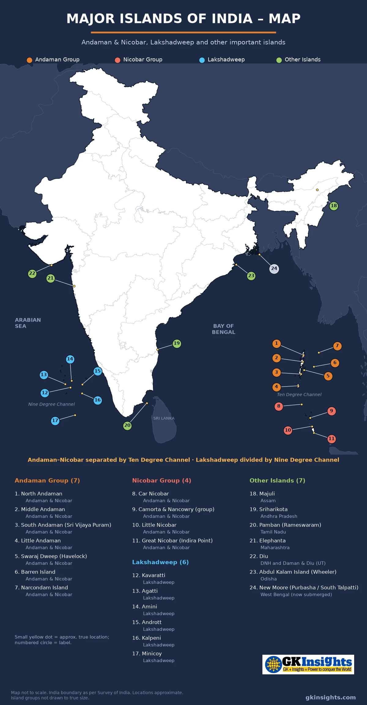
How to Read the Islands of India Map
Each island on the islands of India map has a number and a colour. The colour shows its group:
- Andaman Group (1–7) – North, Middle, South and Little Andaman, Swaraj Dweep (Havelock), Barren Island and Narcondam
- Nicobar Group (8–11) – Car Nicobar, Nancowry / Camorta, Little Nicobar and Great Nicobar (Indira Point)
- Lakshadweep (12–17) – Kavaratti, Agatti, Amini, Andrott, Kalpeni and Minicoy
- Other Islands (18–24) – Majuli, Sriharikota, Pamban, Elephanta, Diu, Abdul Kalam Island and New Moore
The Andaman and Nicobar islands sit in the Bay of Bengal, east of the mainland. Lakshadweep sits in the Arabian Sea, west of Kerala. Majuli is a river island in Assam, not a sea island. Locations are approximate and the map is not to scale. Island groups are not drawn to true size.
Two Major Island Groups of India
As per NCERT Class 11, India: Physical Environment, Chapter 2 (Structure and Physiography), there are two major island groups in India – one in the Bay of Bengal and the other in the Arabian Sea.
The Bay of Bengal group has about 572 islands/islets. These lie roughly between 6°N–14°N and 92°E–94°E. The two principal groups of islets named in NCERT are the Ritchie’s archipelago and the Labyrinth island (NCERT spelling: Labrynth). The whole chain is divided into the Andaman in the north and the Nicobar in the south, separated by the Ten Degree Channel.
NCERT says these islands are believed to be an elevated portion of submarine mountains. Some smaller islands are volcanic in origin. The islands receive convectional rainfall and have an equatorial type of vegetation. The coastal line has some coral deposits and beaches.
NCERT Class 9, Contemporary India – I, Chapter 1 places the Andaman and Nicobar islands to the southeast of the mainland in the Bay of Bengal, and Lakshadweep to the southwest in the Arabian Sea. India’s total coastline, including these islands, is given as 7,516.6 km.
Andaman Group on the Islands of India Map (1–7)
The Andaman Group forms the northern half of the Andaman and Nicobar chain. Port Blair (also called Sri Vijaya Puram), the capital of the Union Territory, is on South Andaman. Duncan Passage separates Little Andaman from South Andaman. The tables below use the same numbers as the islands of India map.
| No. | Island | Union Territory | Location / group | Notes for exams |
|---|---|---|---|---|
| 1 | North Andaman | Andaman & Nicobar | Northernmost large island of the Andaman Group | Saddle Peak (NCERT: 738 m), the highest peak of the UT, is here; Diglipur is the main town |
| 2 | Middle Andaman | Andaman & Nicobar | Between North and South Andaman | Mount Diavolo (515 m, NCERT); Mayabunder is an important town |
| 3 | South Andaman (Port Blair) | Andaman & Nicobar | Capital island of the UT | Port Blair / Sri Vijaya Puram; Cellular Jail (Kalapani); Mount Koyob (460 m, NCERT) |
| 4 | Little Andaman | Andaman & Nicobar | South of Duncan Passage | Separated from South Andaman by Duncan Passage; Hut Bay is the main settlement |
| 5 | Swaraj Dweep (Havelock) | Andaman & Nicobar | Ritchie’s Archipelago, east of South Andaman | Renamed from Havelock in 2018; popular tourist island; nearby Neil Island is Shaheed Dweep (not numbered separately on this map) |
| 6 | Barren Island | Andaman & Nicobar | East of Middle Andaman, in the Andaman Sea | India’s only active volcano; NCERT places it with the Nicobar islands, but exam maps put it in the Andaman Sea with the Andaman Group |
| 7 | Narcondam Island | Andaman & Nicobar | Northeast of North Andaman | Dormant / extinct volcano; known for the Narcondam hornbill |
Peaks, Volcano and Cellular Jail
NCERT lists four important peaks: Saddle Peak (North Andaman – 738 m), Mount Diavolo (Middle Andaman – 515 m), Mount Koyob (South Andaman – 460 m) and Mount Thuiller (Great Nicobar – 642 m). Some exam books give Saddle Peak as about 732 m; follow NCERT’s 738 m unless the question quotes another figure.
NCERT calls Barren Island the only active volcano in India. It is shown as number 6 on the islands of India map. Narcondam (7) is a dormant volcanic island and is often used as a trap option against Barren in Prelims.
Port Blair on South Andaman (3) is best known for the Cellular Jail, built by the British to hold Indian freedom fighters far from the mainland. The jail is a national memorial. Keep the jail with South Andaman on the islands of India map; do not confuse it with Ross Island (Netaji Subhash Chandra Bose Island), which is a smaller island nearby.
Nicobar Group on the Islands of India Map (8–11)
The Nicobar Group lies south of the Ten Degree Channel. Car Nicobar is the northernmost of this group. Great Nicobar is the southernmost and largest of the Nicobars. Indira Point, at the tip of Great Nicobar, is the southernmost point of India.
| No. | Island | Union Territory | Location / group | Notes for exams |
|---|---|---|---|---|
| 8 | Car Nicobar | Andaman & Nicobar | Northern Nicobar, south of Ten Degree Channel | Headquarters of Nicobar district; home of the Nicobarese |
| 9 | Nancowry / Camorta | Andaman & Nicobar | Central Nicobar (Nancowry group) | Good natural harbour; Camorta and Nancowry are twin islands of the central group |
| 10 | Little Nicobar | Andaman & Nicobar | South of the Nancowry group | Smaller island between Camorta and Great Nicobar |
| 11 | Great Nicobar (Indira Point) | Andaman & Nicobar | Southernmost island of India | Indira Point at its tip; Mount Thuiller (642 m, NCERT); Great Nicobar Biosphere Reserve; home of the Shompen |
Indira Point and the 2004 Tsunami
NCERT Class 9 states that the southernmost point of the Indian Union – Indira Point – got submerged under the sea water in 2004 during the Tsunami. Mark Indira Point with Great Nicobar (11) on the islands of India map. NCERT Class 11 also asks students to recall the 26 December 2004 calamity that hit the Andaman and Nicobar Islands.
Great Nicobar faces Sumatra across the Great Channel (also called the Six Degree Channel). This southern tip of India is strategically important because it sits near the approach to the Strait of Malacca.
Lakshadweep on the Islands of India Map (12–17)
The Arabian Sea islands include Lakshadweep and Minicoy. As per NCERT Class 11, they are scattered between 8°N–12°N and 71°E–74°E, about 220–440 km off the Kerala coast. The entire group is built of coral deposits. NCERT says there are approximately 36 islands of which 11 are inhabited. (Many current sources say 10 inhabited islands; both figures appear in exam material – see the note below.)
The capital of the Union Territory is Kavaratti. Agatti has the only airport. Minicoy lies south of the Nine Degree Channel.
| No. | Island | Union Territory | Location / group | Notes for exams |
|---|---|---|---|---|
| 12 | Kavaratti | Lakshadweep | Central Lakshadweep | Capital of the UT; administration shifted here from Kozhikode in 1964 |
| 13 | Agatti | Lakshadweep | West of Kavaratti | Only airport of Lakshadweep |
| 14 | Amini | Lakshadweep | Northern (Amindivi) group | Gives its name to the Amindivi subgroup north of about 11°N |
| 15 | Andrott | Lakshadweep | Easternmost inhabited island, closest to Kerala | Often listed as the largest island by land area (~4.9 sq km) in exam books |
| 16 | Kalpeni | Lakshadweep | South of Andrott / Kavaratti, north of Nine Degree Channel | Part of the Cannanore / Laccadive group south of Amini |
| 17 | Minicoy | Lakshadweep | Southernmost island, south of Nine Degree Channel | Near the Eight Degree Channel towards the Maldives; people speak Mahl (close to Dhivehi) |
Coral Origin, Channels and the Minicoy Area Doubt
Unlike the Andaman and Nicobar islands, which are mostly the tops of submarine mountains, Lakshadweep is a coral archipelago. The islands are low and small. NCERT notes storm beaches of pebbles, shingles, cobbles and boulders on the eastern seaboard.
NCERT says the group is broadly divided by the Nine Degree Channel, north of which is the Amini Island and to the south the Cannanore Island. In practice, Minicoy lies south of the Nine Degree Channel, and the Eight Degree Channel separates Minicoy from the Maldives.
Area note (handle like NCERT vs exam books): NCERT Class 11 says “Minicoy is the largest island with an area of 453 sq. km.” This figure does not match the real land area of the UT, which is only about 32 sq km in total. Exam books usually treat Andrott as the largest island by land area (about 4.9 sq km) and Minicoy as one of the larger islands (about 4.8 sq km). In answers, state what NCERT says when the question is from NCERT; otherwise prefer the ~32 sq km total and Andrott as largest by land area.
On inhabited islands, NCERT says 11; many current government and exam sources say 10. If a question quotes NCERT, use 11; otherwise check the source year.
Other Islands on the Islands of India Map (18–24)
Apart from the two big Union Territories, several other islands appear often in UPSC and State PSC papers. They are numbered 18–24 on the islands of India map.
| No. | Island | State / UT | Type / location | Notes for exams |
|---|---|---|---|---|
| 18 | Majuli | Assam | River island in the Brahmaputra | Often called the world’s largest river island; shrinking due to erosion; satra (Vaishnavite) culture |
| 19 | Sriharikota | Andhra Pradesh | Barrier island between Pulicat Lake and the Bay of Bengal | Satish Dhawan Space Centre (ISRO launch site) |
| 20 | Pamban (Rameswaram) | Tamil Nadu | Between Palk Bay and the Gulf of Mannar | Linked to the mainland by the Pamban Bridge; near Adam’s Bridge (Ram Setu) towards Sri Lanka |
| 21 | Elephanta | Maharashtra | Mumbai Harbour, Arabian Sea | Elephanta Caves – UNESCO World Heritage Site (rock-cut caves, mainly Shaiva) |
| 22 | Diu | Dadra and Nagar Haveli and Daman and Diu | Off the Kathiawar coast, Gujarat side | Former Portuguese colony; now part of the DNHD Union Territory |
| 23 | Abdul Kalam Island (Wheeler Island) | Odisha | Bay of Bengal, off Bhadrak / Balasore coast | DRDO missile test range; renamed from Wheeler Island in 2015 after Dr A.P.J. Abdul Kalam |
| 24 | New Moore (Purbasha / South Talpatti) | West Bengal (disputed / submerged) | Bay of Bengal, near the India–Bangladesh maritime border | Uninhabited sandbar that emerged after the 1970 Bhola cyclone; claimed by both India and Bangladesh; reportedly submerged around 2010 |
Majuli (18) is inland on the Brahmaputra, so do not look for it in the sea on the islands of India map. Sriharikota (19) is a barrier island used by ISRO. Pamban (20) links the temple town of Rameswaram with the idea of Adam’s Bridge. Elephanta (21) is one of the UNESCO World Heritage Sites in India. Abdul Kalam Island (23) is used for missile tests such as Agni. New Moore (24) is kept on exam maps even though reports say it has sunk; say so plainly if asked.
Channels and Passages on the Islands of India Map
Channels are a favourite Prelims topic. The degree in the name is the latitude. Use this table with the islands of India map.
| Channel / passage | Separates | Sea | Exam tip |
|---|---|---|---|
| Ten Degree Channel | Andaman Group (Little Andaman) from Nicobar Group (Car Nicobar) | Bay of Bengal / Andaman Sea | ~150 km wide; most asked Andaman–Nicobar separator |
| Duncan Passage | South Andaman from Little Andaman | Andaman Sea | Inside the Andaman Group; not a “degree” channel |
| Great Channel (Six Degree Channel) | Great Nicobar from Sumatra (Indonesia) | Indian Ocean | Near Indira Point; approach to the Malacca Strait |
| Nine Degree Channel | Main Lakshadweep / Cannanore group from Minicoy | Arabian Sea | NCERT: Amini to the north, Cannanore to the south |
| Eight Degree Channel | Minicoy (India) from the Maldives | Arabian Sea / Laccadive Sea | International separator; do not confuse with Nine Degree |
A quick memory of the three degree channels: 10° = Andaman–Nicobar, 9° = Lakshadweep–Minicoy, 8° = Minicoy–Maldives. Duncan Passage and the Great Channel do not use a degree name in most questions, but the Great Channel is also called the Six Degree Channel in some books.
Andaman–Nicobar vs Lakshadweep: Comparison
NCERT Class 11 asks students to compare the island groups of the Arabian Sea and the Bay of Bengal. Use this table with the islands of India map.
| Feature | Andaman & Nicobar (Bay of Bengal) | Lakshadweep (Arabian Sea) |
|---|---|---|
| Location (NCERT) | Roughly 6°N–14°N, 92°E–94°E | Roughly 8°N–12°N, 71°E–74°E |
| Distance from mainland | Far southeast of the mainland | 220–440 km off the Kerala coast |
| Number (NCERT) | About 572 islands/islets | About 36 islands (11 inhabited, as per NCERT) |
| Origin | Elevated submarine mountains; some volcanic | Coral deposits |
| Highest peak (NCERT) | Saddle Peak 738 m (North Andaman) | Very low coral islands (only a few metres high) |
| Volcano | Barren Island – only active volcano in India | None |
| Climate / vegetation | Convectional rainfall; equatorial vegetation | Tropical monsoon; coconut palms, coral lagoons |
| Capital | Port Blair (South Andaman) | Kavaratti |
| Key channel | Ten Degree Channel (Andaman vs Nicobar) | Nine Degree Channel (main group vs Minicoy) |
Strategic Location, EEZ and Biodiversity
The islands of India map also helps you see why these islands matter beyond map-pointing.
- Strategic location: The Andaman and Nicobar Islands sit near the Strait of Malacca, one of the world’s busiest sea lanes. India’s Andaman and Nicobar Command is a joint command of the Army, Navy and Air Force. Lakshadweep watches the sea lanes of the Arabian Sea towards the Gulf and Africa.
- Exclusive Economic Zone (EEZ): Islands push India’s EEZ far into the Bay of Bengal and the Arabian Sea. Lakshadweep alone is often linked with an EEZ of about 4 lakh sq km in exam notes, much larger than its tiny land area.
- Biodiversity: Andaman and Nicobar have equatorial forests, endemic birds and tribes such as the Jarawa, Onge, Sentinelese and Shompen. Great Nicobar is a biosphere reserve. Lakshadweep is one of India’s four coral reef regions, with lagoons, turtles and many reef fish. Link this with National Parks in India where marine and island parks appear.
- Coastline: NCERT Class 9 gives India’s total coastline including islands as 7,516.6 km. (A later official remeasurement has given a higher figure; for NCERT-based questions use 7,516.6 km.)
Site-wise Facts: Quick Revision from the Islands of India Map
Use this table with the islands of India map for quick revision. The numbers in brackets match the map.
| Fact | Island / place |
|---|---|
| Only active volcano in India | Barren Island (6) |
| Highest peak of A&N (NCERT 738 m) | Saddle Peak, North Andaman (1) |
| Capital of Andaman & Nicobar | Port Blair / Sri Vijaya Puram, South Andaman (3) |
| Cellular Jail | South Andaman (3) |
| Swaraj Dweep (former Havelock) | Swaraj Dweep (5) |
| Southernmost point of India | Indira Point, Great Nicobar (11) |
| Capital of Lakshadweep | Kavaratti (12) |
| Only airport in Lakshadweep | Agatti (13) |
| Largest Lakshadweep island by land area (exam books) | Andrott (15) |
| Southernmost Lakshadweep island | Minicoy (17) |
| Largest river island | Majuli, Assam (18) |
| ISRO launch centre | Sriharikota (19) |
| UNESCO caves near Mumbai | Elephanta (21) |
| DRDO missile test island | Abdul Kalam Island (23) |
| Ten Degree Channel | Between Andaman Group and Nicobar Group |
| Nine Degree Channel | Between main Lakshadweep and Minicoy |
| Eight Degree Channel | Between Minicoy and the Maldives |
| Duncan Passage | Between South Andaman (3) and Little Andaman (4) |
Ritchie’s Archipelago, named in NCERT, includes Swaraj Dweep (5) and nearby islands east of South Andaman. Labyrinth Island (NCERT spelling Labrynth) lies west of South Andaman among mangrove creeks. Neither is numbered separately beyond the islands already on the islands of India map.
UPSC Practice Points on Islands of India Map
Read these points along with the islands of India map. They cover facts often asked in UPSC and State PSC papers.
- India has two major island groups: Andaman and Nicobar in the Bay of Bengal and Lakshadweep in the Arabian Sea (NCERT).
- Bay of Bengal group: about 572 islands/islets between 6°N–14°N and 92°E–94°E; Ritchie’s archipelago and Labyrinth island (NCERT).
- Andaman (north) and Nicobar (south) are separated by the Ten Degree Channel.
- Barren Island is India’s only active volcano; Narcondam is dormant.
- Saddle Peak (North Andaman, 738 m in NCERT) is the highest peak of the Andaman and Nicobar Islands.
- Indira Point on Great Nicobar is the southernmost point of India; NCERT Class 9 says it was submerged in the 2004 tsunami.
- Lakshadweep is coral; about 36 islands; capital Kavaratti; 220–440 km off Kerala.
- Nine Degree Channel divides the main Lakshadweep group from Minicoy; Eight Degree Channel divides Minicoy from the Maldives.
- Duncan Passage: South Andaman and Little Andaman. Great Channel: Great Nicobar and Sumatra.
- Swaraj Dweep = Havelock; Shaheed Dweep = Neil.
- Majuli (Assam) is the largest river island; Sriharikota hosts ISRO’s Satish Dhawan Space Centre; Abdul Kalam Island is a DRDO missile range.
- Coastline including islands: 7,516.6 km (NCERT Class 9).
- Use the plateaus of India map, lakes of India map and rivers of India map together when you revise physical geography.
FAQs on Islands of India Map
How many islands are shown on the islands of India map?
The islands of India map above shows 24 numbered islands: seven in the Andaman Group (1–7), four in the Nicobar Group (8–11), six in Lakshadweep (12–17) and seven other important islands (18–24).
Which channel separates the Andaman Islands from the Nicobar Islands?
The Ten Degree Channel separates the Andaman Group in the north from the Nicobar Group in the south. It lies roughly along 10°N latitude.
Where is India’s only active volcano?
Barren Island in the Andaman Sea is India’s only active volcano. It is number 6 on the islands of India map. Narcondam nearby is a dormant volcano.
What is Indira Point?
Indira Point is the southernmost point of India, at the tip of Great Nicobar Island. NCERT Class 9 notes that it got submerged under sea water during the 2004 tsunami.
What is the capital of Lakshadweep?
Kavaratti is the capital of Lakshadweep. It is number 12 on the islands of India map. Agatti has the only airport.
What is the difference between the Nine Degree and Eight Degree Channels?
The Nine Degree Channel separates Minicoy from the rest of Lakshadweep. The Eight Degree Channel separates Minicoy from the Maldives.
Which is the largest river island in India?
Majuli in the Brahmaputra river in Assam is often called the largest river island. It is number 18 on the islands of India map and is shrinking due to erosion.
Also Check:
– Plateaus of India Map
– Lakes in India Map
– Waterfalls in India Map
– Major Dams in India Map
– National Parks in India Map
– UNESCO World Heritage Sites in India Map
– Rivers of India Map