
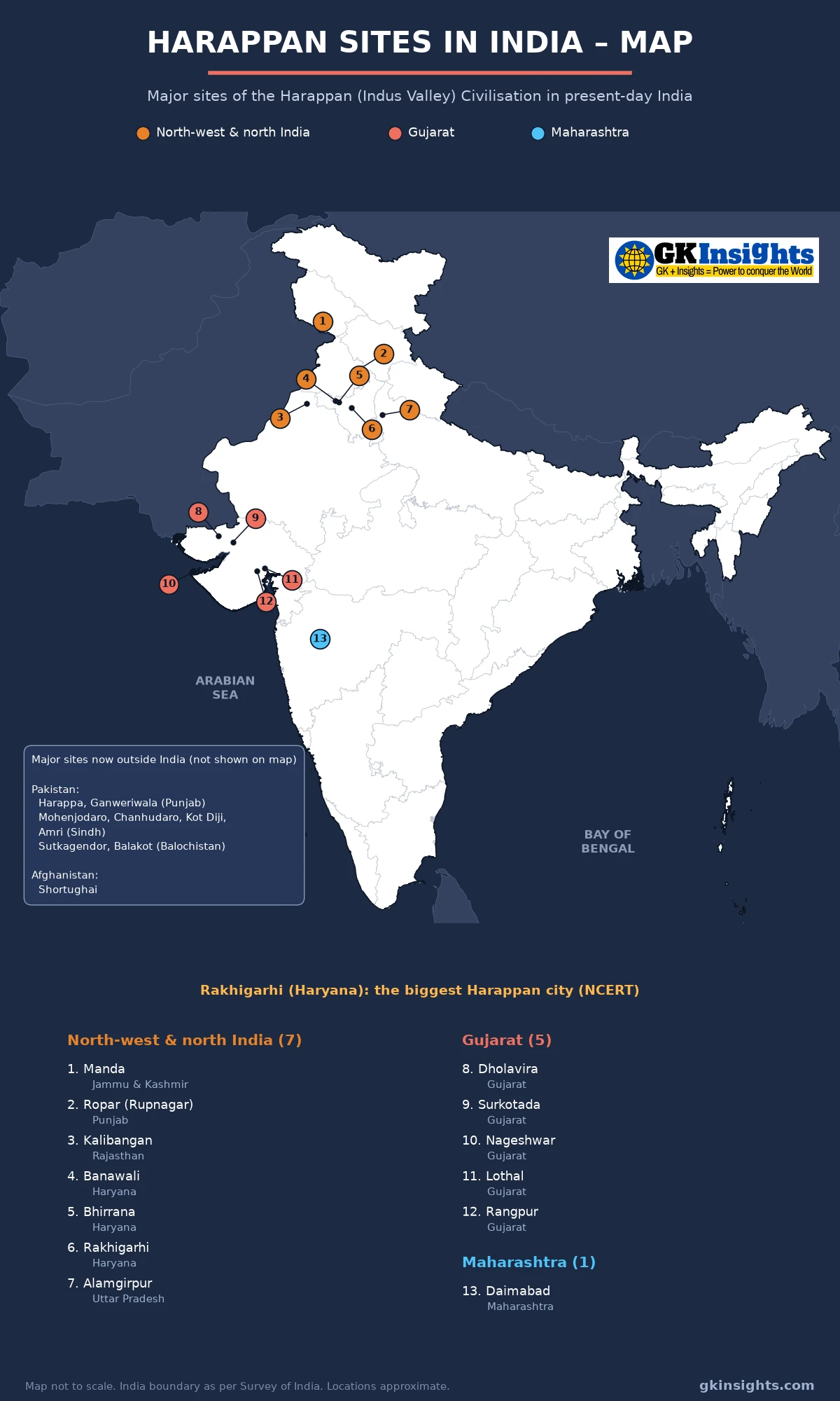
This post explains the Harappan sites map of India with 13 numbered sites, from Manda in Jammu and Kashmir to Daimabad in Maharashtra. For each site you will learn its state, river, the archaeologist who dug it and its main finds, as needed for UPSC and State PSC exams.
The Harappan or Indus Valley Civilisation was the first urban culture of the Indian subcontinent. Its major cities were Harappa and Mohenjodaro, which are now in Pakistan. Many important Harappan sites are also in India: Rakhigarhi, Kalibangan, Dholavira and Lothal are the best known. This Harappan sites map focuses on these sites in present-day India and lists the main sites outside India separately.
Harappan Sites Map of India
How to Read the Harappan Sites Map
Each site on the Harappan sites map has a number and a colour. The colour shows its region: north-west and north India (1–7), Gujarat (8–12) and Maharashtra (13). The tables below use the same numbers.
Only sites in present-day India are marked on the map. Harappa, Mohenjodaro and other sites now in Pakistan and Afghanistan are listed in a box on the map and in a separate table below. Locations are approximate and the map is not to scale. Some sites lie very close to each other, such as Banawali and Bhirrana in Haryana, and Lothal and Rangpur in Gujarat, so read their numbers carefully.
Harappan Civilisation: Names, Time and Area
As per NCERT Class 12, Themes in Indian History Part 1, Chapter 1 (Bricks, Beads and Bones), the Harappan Civilisation is also known as the Indus Valley Civilisation. The name Harappa comes from the place where the civilisation was first identified. Archaeologists use the word “culture” for a group of objects of a distinct style found together in one area and period.
NCERT gives the total time span of the civilisation as 6000 BCE to 1300 BCE, in three phases:
| Phase | Period (NCERT) | Main features |
|---|---|---|
| Early Harappan | 6000 BCE – 2600 BCE | Formative phase; small settlements, distinctive pottery, farming and herding, few large buildings |
| Mature Harappan | 2600 BCE – 1900 BCE | Urban phase and the most prosperous; planned cities, seals, script, standard weights and bricks |
| Late Harappan | 1900 BCE – 1300 BCE | Decline; seals, script and long-distance trade disappear; rural way of life |
Harappan pottery, bricks, seals, weights, beads and copper and bronze objects have been found over a very large area. NCERT lists Afghanistan, Baluchistan, Sind and Punjab in Pakistan, and the Indian states of Jammu and Kashmir, Punjab, Haryana, Rajasthan, Uttar Pradesh, Gujarat and Maharashtra. This is why the Harappan sites map of India covers so many states.
NCERT says more than 2,000 Harappan sites have been discovered so far. Most of them lie between the Indus and the Saraswati river basins, and nearly two-thirds are in the Saraswati basin. The Saraswati is usually identified with the present-day Ghaggar-Hakra river, which flows through Haryana, Rajasthan and Cholistan in Pakistan. Many sites on the Harappan sites map, such as Kalibangan, Banawali, Bhirrana and Rakhigarhi, lie in this basin.
Five Major Harappan Cities
NCERT names five major cities of the Harappan Civilisation: Rakhigarhi, Mohenjodaro, Harappa, Dholavira and Ganweriwala. Two of them, Rakhigarhi (Haryana) and Dholavira (Gujarat), are in India and are marked on the Harappan sites map. The other sites are regional centres, farming villages, ports and craft centres.
Harappan Sites in North-west and North India (1–7)
Most Indian sites on the Harappan sites map lie in the plains of Punjab, Haryana and north Rajasthan, along the Ghaggar and its tributaries. A few lie further out: Manda in the north on the Chenab, Ropar on the Sutlej, and Alamgirpur in the Ganga-Yamuna doab of western Uttar Pradesh.
| No. | Site | State (district) | River / setting | Excavated by | Key finds |
|---|---|---|---|---|---|
| 1 | Manda | Jammu and Kashmir (Jammu) | Right bank of the Chenab, near Akhnoor | J.P. Joshi (ASI), 1976–77 | Northernmost Harappan site in India; Harappan pottery and tools; shown on NCERT Map 1 |
| 2 | Ropar (Rupnagar) | Punjab (Rupnagar) | Left bank of the Sutlej | Y.D. Sharma, 1953–55 | Among the first Harappan sites excavated after Independence; a Harappan sealing (NCERT Fig. 1.22); a burial with a dog placed with a human |
| 3 | Kalibangan | Rajasthan (Hanumangarh) | Left bank of the Ghaggar | B.B. Lal and B.K. Thapar, from 1960 | Ploughed field (Early Harappan), fire altars, fortified citadel and lower town; the name means “black bangles” |
| 4 | Banawali | Haryana (Fatehabad) | Dry bed of the Saraswati (Ghaggar) | R.S. Bisht, 1974 | Terracotta model of a plough (NCERT); barley; fortified town with radial streets |
| 5 | Bhirrana | Haryana (Fatehabad) | Ghaggar basin, near Banawali | L.S. Rao (ASI), 2003–06 | Early levels of the Hakra ware culture, claimed to be among the oldest Harappan levels; a potsherd with a drawing of a dancing girl |
| 6 | Rakhigarhi | Haryana (Hisar) | Dry bed of the Drishadvati (Chautang), in the Ghaggar basin | Amarendra Nath (ASI), 1997; Vasant Shinde, from 2013 | Biggest Harappan city (about 550 hectares, NCERT); DNA from skeletons; cemetery; planned streets and drains |
| 7 | Alamgirpur | Uttar Pradesh (Meerut) | Hindon river, a tributary of the Yamuna | Y.D. Sharma, 1958–59 | Easternmost Harappan site; Late Harappan pottery, beads and terracotta |
On the Harappan sites map, the cluster of Kalibangan, Banawali, Bhirrana and Rakhigarhi shows how important the Ghaggar (Saraswati) basin was. NCERT notes that a ploughed field of the Early Harappan levels has been found at Kalibangan, with two sets of furrows at right angles to each other. This suggests that two crops were grown together.
Rakhigarhi: The Biggest Harappan City
NCERT describes Rakhigarhi in Hisar district of Haryana as the biggest Harappan city, spread over about 550 hectares. DNA was taken from skeletons excavated here, in a study by Deccan College, Pune, with the Centre for Cellular and Molecular Biology, Hyderabad and Harvard Medical School. NCERT says the results show that the Harappans were the indigenous people of the region and that their genetic roots go back to about 10,000 BCE. The study was published in the journal Cell in 2019 (Vasant Shinde and others).
Rakhigarhi is now one of the most studied Harappan sites. Because of its size, it is a frequent question in exams on the Harappan sites map.
Harappan Sites in Gujarat (8–12)
Gujarat has more Harappan sites than any other part of India shown on the Harappan sites map. NCERT says that after Partition, when the major known sites became part of Pakistan, Indian archaeologists searched for sites in India. An extensive survey in Kutch revealed many Harappan settlements. Gujarat sites were close to the sea and to sources of shell, carnelian and other raw materials, so many of them were ports and craft centres.
| No. | Site | State (district) | River / setting | Excavated by | Key finds |
|---|---|---|---|---|---|
| 8 | Dholavira | Gujarat (Kachchh) | Khadir island (Khadir Bet) in the Rann of Kachchh, between two seasonal streams | R.S. Bisht (ASI), from 1990 | One of the five major cities; series of water reservoirs; a large inscription often called a “signboard”; UNESCO World Heritage Site (2021) |
| 9 | Surkotada | Gujarat (Kachchh) | Eastern Kachchh, near Rapar | J.P. Joshi (ASI), 1964 | Small fortified settlement with a citadel and residential area; bones reported as horse bones (this claim is debated) |
| 10 | Nageshwar | Gujarat (Devbhumi Dwarka) | Near the coast, close to Dwarka | Studied by the M.S. University of Baroda | Specialised centre for making shell objects such as bangles, ladles and inlay (NCERT) |
| 11 | Lothal | Gujarat (Ahmedabad) | Bhogava river, a tributary of the Sabarmati, near the Gulf of Khambhat | S.R. Rao, from 1955 | Basin identified as a tidal dockyard; bead-making factory; warehouse; fire altars; site museum |
| 12 | Rangpur | Gujarat (Surendranagar) | Bhadar river, in Saurashtra | M.S. Vats (1931); S.R. Rao (1953–56) | Mature and Late Harappan levels (NCERT Map 4 shows Rangpur II B-C as a Late Harappan area); rice husk in pottery |
Dholavira: The Harappan City in the Rann of Kachchh
Dholavira lies on Khadir island in the Rann of Kachchh. NCERT says the whole settlement at Dholavira and Lothal was fortified, and sections within the town were also separated by walls. It also notes that water reservoirs found at Dholavira may have been used to store water for farming.
In 2021, “Dholavira: a Harappan City” was added to the UNESCO World Heritage List. UNESCO describes it as the sixth largest of more than 1,000 Harappan sites discovered, occupied for over 1,500 years. It has a walled city with a fortified castle and bailey, a ceremonial ground, a middle town and a lower town, and a cemetery to the west. A series of reservoirs lies to the east and south of the citadel. See all the UNESCO World Heritage Sites in India on our map.
Lothal: The Harappan Port Town
Lothal lies in Ahmedabad district of Gujarat, on the Bhogava river near the Gulf of Khambhat. NCERT says Lothal was near the sources of carnelian (from Bharuch), steatite (from south Rajasthan and north Gujarat) and metal (from Rajasthan). Specialised drills for bead-making have been found at Lothal, Chanhudaro and Dholavira. Lothal also has fire altars, and its citadel was built on a height rather than walled off.
The UNESCO Tentative List entry for Lothal (2014) describes a basin about 217 m long and 26 m wide, on the eastern side of the town, identified as a tidal dockyard. It also mentions a warehouse and a bead-making factory in the lower town. This is why Lothal is often called the main port of the Harappans.
Harappan Site in Maharashtra (13)
Daimabad is the southernmost Harappan site on the Harappan sites map. It shows how far south Harappan contact reached, along with sites in Gujarat.
| No. | Site | State (district) | River / setting | Excavated by | Key finds |
|---|---|---|---|---|---|
| 13 | Daimabad | Maharashtra (Ahilyanagar, formerly Ahmednagar) | Left bank of the Pravara, a tributary of the Godavari | M.N. Deshpande (1958–59); S.A. Sali (ASI), 1976–79 | Southernmost Harappan site; Late Harappan levels; a hoard of bronze objects including a chariot with a rider, a rhinoceros, an elephant and a buffalo |
The Daimabad bronzes were found by chance in 1974. Their date is still debated, and some scholars place them after the Harappan period. For exams, Daimabad is mainly asked as the southernmost Harappan site.
Major Harappan Sites Outside India
NCERT says the frontiers of the Harappan Civilisation have little or no connection with present-day national boundaries. With Partition, the major known sites became part of Pakistan. These sites are not marked on the Harappan sites map above, which uses India’s official outline, but they are listed in a box on the map. They are very important for exams.
| Site | Country (province) | River / setting | Excavated by | Key finds |
|---|---|---|---|---|
| Harappa | Pakistan (Punjab, Sahiwal district) | Ravi | Daya Ram Sahni, 1921 | First site to be discovered; badly damaged by brick robbers; granaries; cemetery; R.E.M. Wheeler dug here in 1946 |
| Mohenjodaro | Pakistan (Sindh, Larkana district) | Indus | Rakhal Das Banerji, 1922 | Best-known site; Great Bath; warehouse on the citadel; about 700 wells; planned drains; about 125 hectares (NCERT) |
| Chanhudaro | Pakistan (Sindh) | Indus | N.G. Majumdar, 1931; E.J.H. Mackay, 1935–36 | Tiny craft settlement (less than 7 hectares); bead-making, shell-cutting, metal-working, seal-making and weight-making |
| Kot Diji | Pakistan (Sindh) | Indus | F.A. Khan, 1955 | Early Harappan settlement with a fortification |
| Amri | Pakistan (Sindh) | Indus | N.G. Majumdar, 1929 | Early Harappan and Harappan levels (the Amri-Nal pottery of NCERT Map 2) |
| Ganweriwala | Pakistan (Punjab, Cholistan) | Dry Ghaggar-Hakra bed | Found by M.R. Mughal in surveys from 1974 | One of the five major cities (NCERT); not yet excavated in a big way |
| Sutkagendor | Pakistan (Balochistan) | Dasht river, Makran coast | Aurel Stein, 1927 | Westernmost Harappan site; coastal trading post |
| Balakot | Pakistan (Balochistan) | Near the coast of Sonmiani Bay | G.F. Dales, 1970s | Specialised centre for shell objects (NCERT) |
| Shortughai | Afghanistan | Oxus (Amu Darya) region | French team, 1970s | Northernmost Harappan site overall; near the best source of lapis lazuli; traces of canals (NCERT) |
So the extreme points of the civilisation are: Shortughai in the north (Manda within India), Daimabad in the south, Alamgirpur in the east and Sutkagendor in the west.
Main Features of Harappan Sites
The Harappan sites map shows sites spread over a very large area, but NCERT points out a striking uniformity in their artefacts. The main features are:
- Planned towns: Many settlements were divided into a smaller but higher Citadel and a much larger but lower Lower Town. Streets were laid in a rough grid pattern, intersecting at right angles.
- Bricks: Bricks, sun-dried or baked, had a standard ratio. The length was four times and the breadth twice the height (4:2:1). This ratio was the same from Jammu to Gujarat.
- Drains: The careful drainage system is one of the most distinctive features. Every house had its own bathroom with drains connected to the street drains. Drains were found in smaller settlements too; at Lothal, houses were built of mud bricks but drains of burnt bricks.
- Wells: NCERT gives the number of wells at Mohenjodaro as about 700.
- Seals and script: Seals were made of a stone called steatite. The script has between 375 and 400 signs, is not alphabetical, was written from right to left, and has not yet been deciphered. The longest inscription has about 26 signs.
- Weights: Cubical weights, usually of a stone called chert. Lower weights were binary (1, 2, 4, 8, 16, 32) and higher weights were decimal (160, 200, 320, 640).
- Farming: Wheat, barley, lentil, chickpea and sesame were grown. Millets are found at sites in Gujarat, and rice is relatively rare. Oxen were probably used for ploughing.
- Crafts: Beads of carnelian, jasper, crystal, quartz, steatite, copper, bronze, gold, shell, faience and terracotta. Craft centres included Chanhudaro, Lothal, Dholavira, Nageshwar and Balakot.
Trade and Raw Materials
The Harappans got raw materials from many places. NCERT gives these examples: shell from Nageshwar and Balakot, lapis lazuli from near Shortughai, carnelian from Bharuch, steatite from south Rajasthan and north Gujarat, copper from the Khetri region of Rajasthan, and gold from south India. In the Khetri area, a culture called the Ganeshwar-Jodhpura culture may have supplied copper to the Harappans.
Mesopotamian texts mention contact with regions called Dilmun (probably Bahrain), Magan (perhaps Oman) and Meluhha, which was possibly the Harappan region. Products from Meluhha included carnelian, lapis lazuli, copper, gold and wood.
Site-wise Important Finds: Quick Revision Table
Use this table with the Harappan sites map for quick revision. The numbers in brackets match the Harappan sites map; sites without a number are outside India.
| Find | Site |
|---|---|
| Great Bath, warehouse on the citadel | Mohenjodaro |
| Ploughed field, fire altars | Kalibangan (3); fire altars also at Lothal (11) |
| Terracotta plough model | Banawali (4), and sites in Cholistan |
| DNA study, biggest Harappan city | Rakhigarhi (6) |
| Water reservoirs, large inscription (“signboard”) | Dholavira (8) |
| Dockyard, bead-making factory | Lothal (11) |
| Shell-working centre | Nageshwar (10), Balakot |
| Bead-making craft town without a citadel | Chanhudaro |
| Lapis lazuli source, canals | Shortughai |
| Bronze chariot hoard | Daimabad (13) |
| Sealing found in Punjab | Ropar (2) |
Discovery of the Harappan Sites
NCERT gives a timeline of major developments in Harappan archaeology. The main dates are:
| Year | Event |
|---|---|
| 1875 | Report of Alexander Cunningham on a Harappan seal |
| 1921 | Daya Ram Sahni begins excavations at Harappa |
| 1922 | Excavations begin at Mohenjodaro (Rakhal Das Banerji) |
| 1924 | John Marshall, Director-General of the ASI, announces a new civilisation in the Indus valley |
| 1946 | R.E.M. Wheeler excavates at Harappa |
| 1955 | S.R. Rao begins excavations at Lothal |
| 1960 | B.B. Lal and B.K. Thapar begin excavations at Kalibangan |
| 1990 | R.S. Bisht begins excavations at Dholavira |
| 1997 | Amarendra Nath starts excavations at Rakhigarhi |
| 2013 | Vasant Shinde begins archaeogenetic research at Rakhigarhi |
Cunningham, the first Director-General of the Archaeological Survey of India (ASI), did not realise how old the Harappan seal given to him was. NCERT notes that Wheeler later stressed the need to follow the layers (stratigraphy) of a mound rather than dig in uniform horizontal lines.
Decline of the Harappan Civilisation
NCERT says that by about 1800 BCE most Mature Harappan sites in regions such as Cholistan had been abandoned. At the same time, population moved into new settlements in Gujarat, Haryana and western Uttar Pradesh. This is why Late Harappan sites such as Rangpur and Alamgirpur appear on the Harappan sites map.
Seals, the script, special beads and standard weights disappeared, and long-distance trade declined. Suggested causes include climatic change, deforestation, floods, the shifting or drying up of rivers, and overuse of the land. NCERT adds that no single cause explains the collapse of the whole civilisation, and that a strong unifying element, perhaps the Harappan state, seems to have come to an end.
The Harappan period came after the Stone Age cultures of India. You can read about them in our posts on Palaeolithic sites in India, Mesolithic sites in India and Neolithic sites in India.
UPSC Practice Points on Harappan Sites Map
Read these points along with the Harappan sites map. They cover facts often asked in UPSC and State PSC papers.
- The five major Harappan cities named by NCERT are Rakhigarhi, Mohenjodaro, Harappa, Dholavira and Ganweriwala.
- Rakhigarhi in Hisar district of Haryana is the biggest Harappan city, about 550 hectares in area.
- Harappa was the first Harappan site to be discovered (Daya Ram Sahni, 1921); it lies on the Ravi in Pakistan.
- The Great Bath is at Mohenjodaro, on the Indus in Sindh.
- A ploughed field has been found at Kalibangan, and a terracotta plough model at Banawali.
- Fire altars have been found at Kalibangan and Lothal.
- Lothal, on the Bhogava near the Gulf of Khambhat, had a dockyard and a bead-making factory.
- Dholavira, on Khadir island in the Rann of Kachchh, is known for its water reservoirs and became a UNESCO World Heritage Site in 2021.
- Nageshwar and Balakot were coastal centres for making shell objects.
- Manda is the northernmost Harappan site in India, Daimabad the southernmost and Alamgirpur the easternmost.
- Harappan bricks had a standard ratio of 4:2:1, and the script was written from right to left.
- Rivers on the rivers of India map help you place the sites: Manda on the Chenab, Ropar on the Sutlej, Kalibangan on the Ghaggar and Alamgirpur on the Hindon.
FAQs on Harappan Sites Map
What are the main Harappan sites in India?
The main Harappan sites in India are Rakhigarhi, Banawali and Bhirrana (Haryana), Kalibangan (Rajasthan), Ropar (Punjab), Manda (Jammu and Kashmir), Alamgirpur (Uttar Pradesh), Dholavira, Lothal, Surkotada, Rangpur and Nageshwar (Gujarat) and Daimabad (Maharashtra). All 13 are shown on the Harappan sites map above.
Which is the largest Harappan site in India?
Rakhigarhi in Hisar district of Haryana is the largest Harappan site in India. NCERT calls it the biggest Harappan city, spread over about 550 hectares.
Which Harappan site is in Gujarat and was a port?
Lothal in Ahmedabad district of Gujarat was a Harappan port town. It lies on the Bhogava river near the Gulf of Khambhat and has a basin identified as a tidal dockyard.
Which Harappan site is a UNESCO World Heritage Site?
Dholavira in Kachchh district of Gujarat was inscribed as a UNESCO World Heritage Site in 2021 as “Dholavira: a Harappan City”. Mohenjodaro in Pakistan is also a World Heritage Site.
Which is the southernmost Harappan site?
Daimabad in Ahilyanagar (Ahmednagar) district of Maharashtra, on the Pravara river, is the southernmost Harappan site. It is known for a hoard of bronze objects.
Where was a ploughed field found in the Harappan Civilisation?
A ploughed field was found at Kalibangan in Hanumangarh district of Rajasthan. It has two sets of furrows at right angles to each other, which suggests that two crops were grown together.
Who discovered Harappa and Mohenjodaro?
Daya Ram Sahni began excavations at Harappa in 1921, and Rakhal Das Banerji found seals at Mohenjodaro in 1922. In 1924 John Marshall, Director-General of the ASI, announced the discovery of a new civilisation.
How many Harappan sites are shown on the Harappan sites map?
The Harappan sites map above shows 13 sites in present-day India: seven in north-west and north India, five in Gujarat and one in Maharashtra. Major sites in Pakistan and Afghanistan are listed separately.
Also Check:
– Neolithic Sites in India – Map
– Mesolithic Sites in India – Map
– Palaeolithic Sites in India – Map
– UNESCO World Heritage Sites in India Map
– Rivers of India – Map