
This post explains the plateaus of India map with 14 numbered major plateaus, from the Malwa and Deccan plateaus to Chota Nagpur, Meghalaya and Ladakh. For each plateau you will learn its state, location, rocks, rivers, minerals and soils, as needed for UPSC and State PSC exams.
Most of these plateaus are parts of the old Peninsular Plateau. NCERT calls it one of the oldest and most stable landmasses of India.
Plateaus of India Map
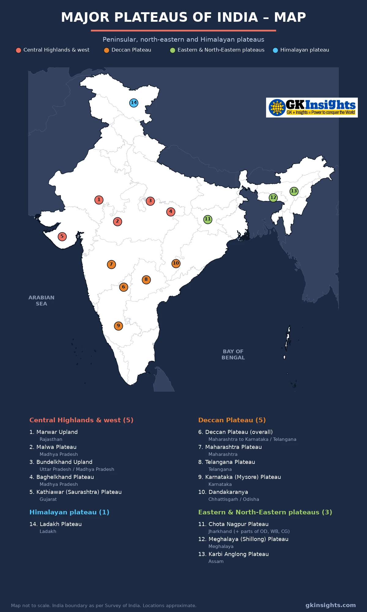
How to Read the Plateaus of India Map
Each plateau on the plateaus of India map has a number and a colour. The colour shows its group: Central Highlands and the west (1–5), the Deccan Plateau (6–10), the eastern and north-eastern plateaus (11–13) and the Himalayan plateau of Ladakh (14). The tables below use the same numbers.
A plateau covers a large area, so each mark on the plateaus of India map shows only its rough centre. Locations are approximate and the map is not to scale. Read it along with a physical map of India to see the hills and rivers that border each plateau.
What is a Plateau?
A plateau is a raised area of land with a fairly flat top and at least one steep side. It stands well above the land around it. Many people describe it as a “table land”.
Plateaus form in different ways. Some are old blocks of hard rock that have been worn down over millions of years, such as the Karnataka and Chota Nagpur plateaus. Some are built by lava flows, such as the Deccan Trap of Maharashtra. Others are lifted high between mountain ranges, such as the Ladakh plateau.
In India, plateaus matter because they hold most of our minerals, give rise to many rivers and carry black, red and laterite soils. This is why the plateaus of India map links closely with the maps of minerals, rivers and soils.
Classification of the Plateaus of India
As per NCERT Class 11, India: Physical Environment, Chapter 2, the Peninsular Plateau rises from about 150 m above the river plains to 600–900 m. It forms an irregular triangle. The Delhi ridge, the Rajmahal hills, the Gir range and the Cardamom hills mark its outer edges. NCERT divides it into three broad groups:
- The Deccan Plateau, south of the Narmada
- The Central Highlands, north of the Narmada
- The North-eastern Plateau, the Meghalaya and Karbi Anglong plateaus
NCERT also says the Peninsula is made of a series of patland plateaus, such as the Hazaribagh, Palamu, Ranchi, Malwa, Coimbatore and Karnataka plateaus. The general slope of the plateau is from west to east, which is why most big Peninsular rivers flow into the Bay of Bengal.
The plateaus of India map follows this plan with small changes. Chota Nagpur, which NCERT treats as the eastern extension of the Central Highlands, is grouped here with the north-eastern plateaus as the eastern plateaus. Kathiawar, a lava plateau in Gujarat, is placed with the western group. The Ladakh plateau is added as a separate Himalayan group, because it is not part of the Peninsula at all.
Central Highlands and Western Plateaus (1–5)
The Central Highlands lie north of the Narmada. NCERT Class 9 says they cover a major area of the Malwa plateau and are wider in the west but narrower in the east. Their eastward extensions are locally known as Bundelkhand and Baghelkhand. Rivers here, such as the Chambal, Sind, Betwa and Ken, flow from south-west to north-east, which shows the slope of the land.
| No. | Plateau | State(s) | Location and extent | Key features (rocks, minerals, rivers, soils) |
|---|---|---|---|---|
| 1 | Marwar Upland | Rajasthan | East of the Aravalli range, in south-central Rajasthan | Sandstone, shale and limestone of the Vindhyan system; drained by the Banas and its tributaries; slopes gently eastward |
| 2 | Malwa Plateau | Madhya Pradesh (also parts of Rajasthan and Gujarat) | Between the Aravalli in the north-west, the Vindhyas in the south and Bundelkhand in the east | Mostly basalt lava, an extension of the Deccan Trap; black soil; drained by the Chambal, Betwa, Kali Sindh and Parbati; Chambal ravines on its northern edge |
| 3 | Bundelkhand Upland | Uttar Pradesh and Madhya Pradesh | Between the Yamuna in the north and the Vindhyan scarps in the south | Old granite and gneiss (Bundelkhand gneiss); drained by the Betwa, Dhasan and Ken; red and mixed soils; dry and drought-prone |
| 4 | Baghelkhand Plateau | Madhya Pradesh (edges in Chhattisgarh) | East of the Maikal range, around Rewa, Satna and Sidhi | Sandstone and limestone in the north, granite in the south; the Son flows along its north; forms a divide between the Son and Mahanadi river systems |
| 5 | Kathiawar (Saurashtra) Plateau | Gujarat | Peninsula between the Gulf of Kachchh and the Gulf of Khambhat | Central part of Deccan lava; Gir and Girnar hills; rivers such as the Bhadar and Shetrunji flow outward in all directions; black soil; Gir is the home of the Asiatic lion |
On the plateaus of India map, this western group sits in Rajasthan, Gujarat and Madhya Pradesh. NCERT Class 11 gives the general height of the Central Highlands as 700–1,000 m, sloping towards the north and north-east. It also notes that the north-western part has ravines and gorges, such as those of the Chambal, Bhind and Morena.
The Malwa plateau is one of only two plateaus named in the NCERT Class 9 map-skills exercise, the other being Chota Nagpur. So it is worth marking both on a blank plateaus of India map.
Deccan Plateau and its Sub-divisions (6–10)
The Deccan Plateau is the largest part of the Peninsular Plateau and is usually called the largest plateau of India. NCERT Class 9 (Contemporary India I, Chapter 2) describes it as a triangular landmass south of the Narmada. The Satpura range forms its broad base in the north, while the Mahadev hills, Kaimur hills and Maikal range form its eastern extensions. The Western Ghats and Eastern Ghats mark its western and eastern edges. On the plateaus of India map, the overall Deccan label is number 6, and its main parts are 7 to 10.
The Deccan is higher in the west and slopes gently eastward. So the Godavari, Krishna and Kaveri rise in the Western Ghats and flow east into the Bay of Bengal. You can trace these rivers across the plateaus of India map.
| No. | Plateau | State(s) | Location and extent | Key features (rocks, minerals, rivers, soils) |
|---|---|---|---|---|
| 6 | Deccan Plateau (overall) | Maharashtra, Karnataka, Telangana, Andhra Pradesh, Tamil Nadu and nearby states | South of the Narmada, between the Western and Eastern Ghats | Basalt in the north-west, old granite and gneiss elsewhere; Godavari, Krishna and Kaveri flow east; black and red soils |
| 7 | Maharashtra Plateau | Maharashtra | Interior Maharashtra, east of the Sahyadri (Western Ghats) | Made of Deccan Trap basalt in flat-topped, step-like layers; deep black (regur) soil good for cotton; drained by the Godavari, Bhima and Krishna |
| 8 | Telangana Plateau | Telangana | Interior Telangana, around Hyderabad | Old granite and gneiss; red soils; many irrigation tanks; Godavari and Krishna; coal of the Godavari valley (Singareni) |
| 9 | Karnataka (Mysore) Plateau | Karnataka | South of the Krishna-Tungabhadra, between the Western and Eastern Ghats | Old Dharwar rocks rich in iron ore and gold; hilly Malnad in the west and rolling Maidan in the east; drained by the Kaveri and Tungabhadra; red and laterite soils |
| 10 | Dandakaranya | Chhattisgarh and Odisha (edges in Andhra Pradesh and Telangana) | Bastar region of Chhattisgarh and Koraput-Malkangiri of Odisha | Dense forest and tribal homeland; drained by the Indravati and Sabari; Bailadila iron ore and Koraput bauxite lie in or near it |
Deccan Trap
NCERT Class 9 calls the black soil area of the Peninsula the Deccan Trap. It is of volcanic origin, so the rocks are igneous. Over time these basalt rocks have been worn down to form black soil. This is why the Maharashtra and Malwa plateaus on the plateaus of India map are India’s main cotton areas. Read more in Soil Types in India.
NCERT Class 11 also notes that the plateau has seen repeated uplift, sinking and faulting. It names the Bhima fault for its repeated earthquakes. The highest peak of the Peninsular plateau is Anaimudi (2,695 m) in the Anaimalai hills, followed by Dodabetta (2,637 m) in the Nilgiris. See Mountains, Ranges and Hills of India for these ranges.
Eastern and North-Eastern Plateaus on the Map (11–13)
NCERT Class 11 says that when the Indian plate pushed north-east during the rise of the Himalayas, a large fault formed between the Rajmahal hills and the Meghalaya plateau. Rivers later filled this gap with sediment. Today the Meghalaya and Karbi Anglong plateaus stand apart from the main Peninsular block, as the plateaus of India map shows.
| No. | Plateau | State(s) | Location and extent | Key features (rocks, minerals, rivers, soils) |
|---|---|---|---|---|
| 11 | Chota Nagpur Plateau | Jharkhand (with parts of Odisha, West Bengal and Chhattisgarh) | Eastern end of the Peninsula, south of the Rajmahal hills | Made of smaller plateaus such as Ranchi, Hazaribagh and Palamu; drained by the Damodar, Subarnarekha, North Koel and Barakar; coal, iron ore, mica, copper, bauxite and uranium; red and laterite soils; many waterfalls |
| 12 | Meghalaya (Shillong) Plateau | Meghalaya | North-east of the Bangladesh plain, south of the Brahmaputra valley | Garo, Khasi and Jaintia hills, named after the tribes living there; coal, iron ore, sillimanite, limestone and uranium; very heavy rain, so the surface is highly eroded |
| 13 | Karbi Anglong Plateau | Assam | East of the Meghalaya plateau, south of the Brahmaputra | Extension of the Meghalaya plateau, also called the Karbi (Mikir) hills; drained by the Kopili and Dhansiri; Kaziranga lies along its northern foot |
On the plateaus of India map, number 11 sits in Jharkhand, but the plateau spreads into four states. NCERT calls the Chota Nagpur plateau a large reserve of mineral resources. The Damodar valley here holds India’s main Gondwana coalfields, such as Jharia and Raniganj. For mines on each plateau, see the Minerals in India Map. Rivers falling off the plateau edges give waterfalls such as Hundru and Dassam; read Waterfalls in India Map.
NCERT Class 11 notes that the Meghalaya plateau gets maximum rainfall from the south-west monsoon. Cherrapunji shows a bare rocky surface with no permanent plant cover, because heavy rain has washed the soil away. Link this with Climate of India.
Himalayan Plateau: Ladakh (14)
The Ladakh plateau is the only plateau on the plateaus of India map that is not part of the Peninsula. It lies in the Union Territory of Ladakh, between the Karakoram range in the north and the Ladakh and Zaskar ranges in the south. The Indus flows through it.
| No. | Plateau | State(s) | Location and extent | Key features (rocks, minerals, rivers, soils) |
|---|---|---|---|---|
| 14 | Ladakh Plateau | Ladakh (UT) | North of the Great Himalaya, between the Karakoram and the Ladakh-Zaskar ranges | Highest plateau of India, mostly above 3,000 m; cold desert in the rain shadow of the Himalayas; very little rain; drained by the Indus and its tributaries; high plains such as Depsang and Lingzi Tang |
On the plateaus of India map, Ladakh is shown in its own colour at the far north. Ladakh is very young compared with the Peninsular plateaus. It was raised high during the building of the Himalayas. So its rocks, climate and soils are very different from those of the Deccan. Many passes cross this region; see Important Mountain Passes in India.
Importance of the Plateaus of India
The plateaus of India map is not just a list of names. Each plateau shapes the minerals, rivers, soils and people of its region.
- Minerals: The Chota Nagpur, Meghalaya, Karnataka and Dandakaranya plateaus hold most of India’s coal, iron ore, bauxite, manganese, mica and gold.
- Rivers and water: Many rivers rise on the plateaus. Their falls and gorges give good sites for dams and power plants, such as those in Hydroelectric Power Plants in India Map.
- Soils and farming: Black soil of the Deccan Trap supports cotton, sugarcane and pulses. Red and laterite soils support millets, groundnut and plantation crops.
- Forests and wildlife: Dandakaranya, Chota Nagpur and the Meghalaya plateau have large forests and tribal homelands. Gir on the Kathiawar plateau is a famous national park.
- Problems: Thin soils, uneven rain, ravines in the Chambal area and droughts in Bundelkhand limit farming. Mining also causes loss of forest and displacement of people.
Comparison Table of Major Plateaus of India
Use this comparison table with the plateaus of India map for quick revision. The numbers in brackets match the plateaus of India map.
| Plateau | Main rock | Main soil | Main rivers | Known for |
|---|---|---|---|---|
| Malwa (2) | Basalt (lava) | Black | Chambal, Betwa | Black soil, Chambal ravines |
| Bundelkhand (3) | Granite, gneiss | Red and mixed | Betwa, Ken | Drought-prone upland |
| Maharashtra (7) | Deccan Trap basalt | Black (regur) | Godavari, Bhima | Cotton, step-like trap hills |
| Telangana (8) | Granite, gneiss | Red | Godavari, Krishna | Tank irrigation, Singareni coal |
| Karnataka (9) | Dharwar schists, gneiss | Red, laterite | Kaveri, Tungabhadra | Iron ore and gold, Malnad and Maidan |
| Chota Nagpur (11) | Old crystalline rocks, Gondwana coal beds | Red, laterite | Damodar, Subarnarekha | Storehouse of minerals |
| Meghalaya (12) | Old crystalline rocks | Laterite, red | Small rivers to the Brahmaputra and Bangladesh | Very heavy rain, coal and limestone |
| Ladakh (14) | Himalayan rocks | Thin, desert | Indus | Highest plateau, cold desert |
UPSC Practice Points on Plateaus of India Map
Read these points along with the plateaus of India map. They cover facts often asked in UPSC and State PSC papers.
- The Deccan Plateau is usually called the largest plateau of India, and Ladakh the highest.
- The Central Highlands lie north of the Narmada; the Deccan Plateau lies south of it.
- Bundelkhand and Baghelkhand are the eastward extensions of the Central Highlands, and Chota Nagpur extends further east.
- The Chota Nagpur plateau is drained by the Damodar and is called the storehouse of minerals of India.
- The Meghalaya and Karbi Anglong plateaus are extensions of the Peninsular plateau, cut off by the Garo-Rajmahal gap.
- The Garo, Khasi and Jaintia hills, from west to east, are parts of the Meghalaya plateau.
- The Deccan Trap is of volcanic origin and gives black soil.
- The Peninsular plateau slopes from west to east, so most of its rivers drain into the Bay of Bengal. See Rivers of India.
FAQs on Plateaus of India Map
Which is the largest plateau in India?
The Deccan Plateau is usually called the largest plateau in India. It is a triangular landmass south of the Narmada, between the Western Ghats and the Eastern Ghats.
Which is the highest plateau in India?
The Ladakh plateau in the Union Territory of Ladakh is the highest plateau in India. It is a cold desert lying between the Karakoram and the Ladakh-Zaskar ranges.
Which plateau is called the storehouse of minerals of India?
The Chota Nagpur plateau, mainly in Jharkhand with parts of Odisha, West Bengal and Chhattisgarh, is called the storehouse of minerals of India. It has coal, iron ore, mica, copper, bauxite and uranium.
What are the three divisions of the Peninsular Plateau?
As per NCERT Class 11, the Peninsular Plateau is divided into the Deccan Plateau, the Central Highlands and the North-eastern Plateau.
Where is the Malwa plateau located?
The Malwa plateau lies mainly in western Madhya Pradesh, with parts in Rajasthan and Gujarat, north of the Vindhya range. It is made of lava rocks with black soil and is drained by the Chambal and Betwa.
How many plateaus are shown on the plateaus of India map?
The plateaus of India map above shows 14 major plateaus in four groups: five in the Central Highlands and west, five in the Deccan, three in the east and north-east, and one in the Himalayas (Ladakh).
Which hills form the Meghalaya plateau?
The Meghalaya plateau is made of the Garo, Khasi and Jaintia hills, from west to east. They are named after the tribes living there.
Also Check:
– Mountains, Ranges and Hills of India – Map
– Rivers of India – Map
– Soil Types in India – Map
– Minerals in India Map
– Important Mountain Passes in India – Map